Monday, March 31, 2008

March 30th Chase Log


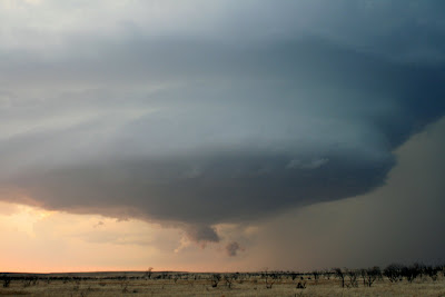
Wow, what an amazing day and it helped me a little bit remember why I was so happy to move out here. This will be edited over the next couple of days as I will have more time to give a complete description of the days chase. For now I will leave a couple of photos for you as we didn't get a tornado as there was not a tornado reported anywhere till well after dark. However there were some nasty supercells with some well defined mesos and wall clouds. My buddy and I positioned ourselves perfectly as the spot I picked out two days prior happened to be the perfect spot. We stayed out of the hail for the most part got hit by some pea size hail but we did get to see a beautiful meso/mothership. Overall It was a blast and I'm looking forward to chasing to the east today. I'll have a full chase log and analysis over the next couple of days. For the time being here is a link to my pictures from the chase MARCH 30th
Sunday, March 30, 2008

Severe Weather Still looking Possible


Currently most of southwest Oklahoma is in stratus clouds and fog however looking at the latest visible satellite there is some good clearing to the southwest. This clearing now looks like it will be over southwest Oklahoma by 1pm. This will likely help temperatures get into the upper 70s to low 80s across the area. Latest RUC shows a dryline bulge after 4pm across western Oklahoma with a triple point just north of that. Precip according to the RUC also develops after 5pm across that area with over 2500 joules of CAPE. Now what I'm worried about besides the time of initiation is the amount of upper level support and backing of the surface winds. Right now there seems to be a impulse over western New Mexico which could be the trigger this afternoon. However per the 12z NAM and latest RUC the 850mb winds and 500mb don't really start turning and increasing till after 0z (7pm). So even if storms can fire will they have enough low level and upper level support to be tornadic. All models continue to show increasing instability and upper level winds after dark across the area. So storms can get going ahead of the dry line then they will likely be severe well into the evening. My plan right now is to wait and see what the early afternoon conditions are. My target location for the past two days has been the Hobart area. Right now it is looking quite favorable spot however the trend has pushed things a little west and maybe a little south. I'll have a update right before I head out roughly around 3pm this afternoon.

Saturday, March 29, 2008

Potential tornadic outbreak possible Sunday Evening and Monday


Good Saturday morning, Looking at the morning models it is looking like a outbreak of severe weather is likely Sunday evening into Monday evening. For the Texoma area there will be one maybe two different time chances of severe weather. The first time frame will be after 5pm Sunday afternoon lasting well into the evening hours. The second time frame will be after 1pm to around 6pm. The morning models show very little precip breaking out in Oklahoma during the afternoon or evening Sunday. The cap looks to be strong and the upper level energy lacking a little. So with weak convergence during the daylight hours and lift at the mid levels thunderstorms could not develop until overnight. One thing that isn't questionable is that the parameters for a major tornadic event across western Oklahoma and southern Kansas look high. If any storms do break the cap and can develop they will likely be tornadic and some could produce very long liver and strong tornadoes. I will post more on this later with some graphic once I get a chance to look over more information. Expect alot of blogs over the next couple of days.

Monday, March 24, 2008

Severe Weather still just rumors....

Since March 2nd our weather pattern for the most part has been pretty cool and quiet in terms of severe weather. We did see some severe weather in the way of hail storms and flash flooding on March 17th. Looking at the week and weeks beyond the pattern doesn't look favorable for a big severe weather outbreak. However we're getting into late March and the conditions are becoming more favorable in terms of warmth and moisture. This week we do have a slight risk of severe weather across mainly eastern Oklahoma, Arkansas and southern Missouri on Thursday afternoon. There might be another chance of severe weather again on Sunday. The overall pattern isn't the most favorable for large storm systems and severe weather. Looking ahead to the first two weeks of April the pattern will likely slowly change so the that instead of a northwest flow across the plains that a trough will form over the west and a weaker trough into the northeast. This will allow storm systems to develop along the lee side of the Rockies. Also allow plenty of Gulf of Mexico moisture to return for any of the disturbances interact with. So for the near term nothing to exciting expected but will have to watch things as will see at least some instability and warm temperatures over the next week.

Saturday, March 15, 2008

Wakita and Greensburg Trip


This Wednesday and Thursday Dan Zarrow and I went up to Wakita, Oklahoma then to Greensburg, Kansas. Wakita is the town where parts of the movie Twister was filmed in. It is best know for the place where Aunt Meg lived and the tornado that demolished the small town. In the town they have opened the Twister Museum dedicated to the movie. The museum as you can see in the pictures is full of pictures, posters and various stuff.
Our second stop was to the small town of Greensburg, Kansas. May 4th 2007 this town was about 95% destroyed by a EF-5 tornado. It was a clear eye opener for how a tornado can change someones life for ever. The town seems to have a very clear plan on how it wants to rebuild. In which they want the city to be known as being Green and environmentally friendly. As you will see by the pictures they're complete streets that have nothing left than empty lots.
Click on the Link for Pictures Wakita and Greensburg Pictures

Monday, March 10, 2008

Severe Weather Pattern Setting Up?


Looking at the Ensembles over the last week they have been pretty constant in bringing a nice size trough into the west. Then pumping a ridge in the center part of the nation then trying to put another trough into the Northeast. If this would set up it would allow the Gulf of Mexico to open up. Allowing very warm and moist air to rush north into the Central Plains and into the Mississippi Valley. Then would create pressure falls along the Lee side of the Rockies. Creating very stormy weather for the middle part of the nation including right here in Texoma. The longer range models such as the European and GFS now are jumping abroad at this idea. Both have a storm developing this coming weekend and slowly moving into the Plains. This would create 1-2 days of severe weather in the western Central Plains. So you bet I'll be watching this closely over the next week as typically severe weather really ramps up by the 20th. So climatology is also on our side with this pattern and La Nina years have typically brought severe weather earlier then non La Nina years. So stayed tuned as I will have another update later this week. Take care and by the way I just received my brand new Canon Xti Camera...Love it and can't wait to chase with it!

Monday, March 3, 2008

Chase day #1 is in the bag with some ok results


Chase #1 of 2008 is done and hopefully many more to come. The conditions were marginal for tornadic storms today but felt it was worth the chase. It was good way to work out the kinks and get a lay of the land out here.


I'll give you a little analysis and overview of my day. Then I'll post a link to my pictures and there I posted a brief description on each picture.


Started out the day heading west out of Lawton about 2:30pm. My original destination was going to be Altus, Oklahoma but decided after watching the radar to stop halfway in Synder, OK. While sitting in Synder I decided to stop at filling station and wouldn't you know who is in the parking lot by Mr. Bryan Smith. After talking to him for a while and watching the storms for a while. His group decided to head north at a storm that was starting to look promising about 35miles north of Synder. I decided to head south about 5 miles south of Synder to play one of the southern storms in the better environment. Eventually one cell started to look healthy and that's where my photos start at. This head just north of Synder in the mountain view area. I drive just north of Mountain view and notice very heavy rain/hail core while to the west of that a very hard updraft base. This eventually starts to pull scud clouds and quickly develops a wall cloud. After 5 or so minutes begins to moderately rotate as it develops a inflow band to it. The wall cloud continues to head northeast as it begins to weaken but still has very fast movement straight up from the ground. The storms gets rain wrapped and quickly moves out of my view and of course goes into a State Park. I did see a couple more storms but nothing severe or really worth mentioning as my daylight goes away.


Click on the link here to view Chase #1

Sunday, March 2, 2008

A Very Good Sign


Brand new mesoscale discussion has been issued across western Oklahoma. It discusses the possibility of severe thunderstorms developing by 5pm. They also say how low level instability has increased with some daytime heating. That with a large curvature of the hodographs that any storm will be capable of producing tornadoes. You can read the entire discussion by clicking here

Chase mode is in effect for later this afternoon


Good Sunday afternoon everyone as it is a go for storm chasing this afternoon. Conditions look likely for severe weather however it is still marginal for tornadic storms. Currently outside my apartment it is mostly cloudy with a break or two in the clouds. Temperatures have continued to rise despite the cloud cover. The temperature is 73 with a dewpoint of 56 and a strong SSE wind at 25mph gusting to 34mph.
The top graphic is the latest SPC outlook which i feel is about right on in our area. As thunderstorms will likely develop by 5pm along the Tx panhandle/Oklahoma border. The second graphic is the latest Craven index which paints a nice bulls eye for severe weather over SW Oklahoma by 8pm. The last graphi is the latest visible that shows one piece of energy lifting northeast while the second one enters the panhandle. Also we're starting to see clouds clear out over the Texoma area.
I will likely be leaving my apartment or the station by 3pm central time to position myself. At this time I'm not sure if it will be just me or if I will be with a photog from the station. Luckily it doesn't look that long of drive as right now I will likely set up just north of the Red River about 30 mins south of Lawton. I'll try to update this as many times as I can this afternoon.


Saturday, March 1, 2008

First chase day is looking like a go!


Here is the Latest Day 2 outlook from the SPC... ( I placed a dot where Lawton is)
The severe threat for tomorrow is starting to look a little more interesting as the models have tended to slow down the cold front. At the same time developed the low pressure a little further north into the Texas Panhandle. This will help increase the moisture, instability and delay the development of post frontal squall line in the Texoma area. The 18z NAM just came out and it continues to tend toward the GFS resolution. It also has reintroduced the chance of super cells and maybe a tornadic risk. At this time the 0-1km shear is marginal and the upper level winds are not the strongest. However looking at the soundings and models the shortwave coming out of the Pacific doesn't seem to being handled well. So there could still be a change in the setup and will likely see the entire setup overall at the 0z models since they actually use weather balloons and upper air soundings. So at this time I do plan on chasing tomorrow and it will likely be around the Wichita Falls area. That is after I get off work as I work in the morning and will be on call until 2pm. So expect another update later this evening or sometime tomorrow morning. Hopefully things really start to add up and we get some really good moisture advection in here overnight.