Tuesday, October 26, 2010

Historic Storm Continues to Deepen!

This is a storm now stronger than the infamous "Edmund Fitzgerald" storm in Nov. 1975 and an even stronger version almost exactly 23 years after that in Nov. 1998. Its central pressure is also on par with the infamous Superstorm of 1993, and is lower than the last 4 hurricanes of the 2010 Atlantic hurricane season. Currently the pressure is down to 957mb which puts it second on the list of lowest pressure ever in this part of the region. To reach number one it will have to fall another 7 millibars to beat the Great Ohio Blizzard of 1978. Forecast show it reaching 955mb before starting to fill back in.
Here is a map of all the currents wa

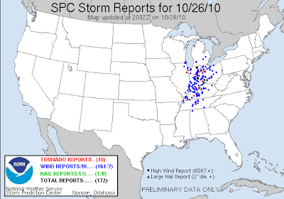
It continues to spawn numerous severe t'storms with damaging winds and tornadoes from Ohio and Pennsylvania south to Mississippi,Alabama and Georgia. Here is the latest map of all the storm reports so far.  
This threat will continue well into the evening as the low pressure finally starts to weaken and move into southern Canada.

Life Threatening Event Unfolding Across Ohio Valley

SPC Now has a large portion of Indiana under a High Risk for later this morning. As a large line of severe t'storms continue to race to the east across Illinois currently. This will meet up with increasingly warm and moist air as the morning wears on. Creating a very potent and a potentially life threatening situation with damaging winds and strong tornadoes looking likely. I'll have more details later this morning when I get time. I'm currently watching this from work but am very impressed by some of the parameters I'm looking at. These storms will be rocketing along at over 60 mph and the high winds/tornadoes will be surrounded by heavy rains making them nearly impossible to see. BE CAREFUL AND PAY ATTENTION TO THE LATEST WARNINGS!

Monday, October 25, 2010

Leaf Stripping Wind Machine Starts to Crank Up

Statement from the Chicago National Weather Service
PUBLIC INFORMATION STATEMENT
NATIONAL WEATHER SERVICE CHICAGO/ROMEOVILLE IL
1030 AM CDT MON OCT 25 2010

HOW THE UPCOMING CYCLONE RANKS AMONG OTHER NOTABLE CYCLONES OVER THE
GREAT LAKES.


RANK EVENT DATE MINIMUM CENTRAL PRESSURE
1. GREAT OHIO BLIZZARD 1/26/1978 950 HPA /28.05 IN/
2. UPCOMING EVENT 10/26-27/2010 959 HPA* /28.35 IN/
3. ARMISTICE DAY STORM 11/11/1940 967 HPA /28.55 IN/
ANNIVERSARY STORM 11/10/1998 967 HPA /28.55 IN/
4. CYCLONE OF 1913 11/7-9/1913 968 HPA /28.60 IN/
/AKA WHITE HURRICANE/
5. EDMUND FITZGERALD STORM 11/10/1975 980 HPA /28.95 IN/
* AVERAGE AMONG SEVERAL CURRENT FORECAST MODELS


Likely one of the deepest areas of low pressure ever recorded in the Great Lakes region by tomorrow afternoon is starting to really deepen. As the pressures continue to fall, winds continue to increase all across the Plains and eventually to the east across the Ohio valley and Great Lakes. Winds in the atmosphere are extremely strong with this storm system from top to bottom. So winds outside of any t'storm could exceed 50 mph today across the Plains and over 70mph across the Great Lakes and Ohio Valley. Unfortunately my computer is not allowing me to post any pictures to my blog but I'll try to get them on later.

Now of course the severe weather threat is on the higher side with this storm system based on the difference of temperatures, wind energy and plenty of moisture surging north from the Gulf of Mexico. Today's target area is across the mid Mississippi Valley from eastern Iowa and Missouri during this afternoon then quickly racing east across Wisconsin, Illinois and Arkansas overnight.

Then by tomorrow morning the likely squall line will continue to surge eastward across Indiana, southern Michigan, Kentucky and Ohio during the day on Tuesday. This line will have numerous reports of damaging winds and the possibility of brief tornadoes. This is a possible dangerous situation across the upper and middle Mississippi Valley and into the Great Lakes and Ohio Valley on Tuesday. Please make sure you keep up with the weather as conditions will change very quickly.

Thursday, October 21, 2010

Severe Threat Still In The Cards

An Upper Level Low and strengthening jet stream overhead will bring widespread showers and t'storms to the Southern Plains over the next 24 hours. This afternoon and through the evening some severe weather is possible across the Texas Panhandle into far western north Texas and western Oklahoma. Hail up to golf balls and gusty winds up to 65 mph will be possible. The tornado threat does look very low but could rule out a couple tornadoes warning for a quick spin up.

On Friday the upper level low continues to pivot and lift northeast as a strong mid level jet streaks across Texas and Oklahoma. This will allow for moderate shear to take shape not only at mid levels but down at the ground creating some large hodos. The key to the severe weather setup tomorrow will be timing and instability. If parts of western Oklahoma to can warm and break into some sunshine with CAPE climbing over 1,500 joules. Then the severe weather threat looks to be there with large hail and some tornadoes in the individual storms. Currently SPC, like expected posted a slight risk yesterday and has expanded it today for a slightly greater threat. They as well have questions on the amount of heating and how much stable air will be left from the morning rain. Unfortunately its not letting me post any maps or outlooks but you can see them here at http://www.spc.noaa.gov/

My co-worker meteorologist Austin Bowling and I plan on being out in the field by early afternoon tomorrow. So plan on another update tomorrow morning and hopefully watching us on our live streaming dashcam tomorrow afternoon.  Have a great Thursday evening!

Tuesday, October 19, 2010

The Second Season about to start up!

 With the Spring severe weather season a distant memory, the Fall severe weather season(also know as the second season) is about to take off. A strengthening jet for the past week over the Pacific is about to crash into North American. This along with the gathering cold air across Canada will set up a battle zone across the US for the next two weeks. Currently an upper level low sits across the desert southwest but will get nudged out eastward by tomorrow. This will set off some severe weather across New Mexico tomorrow afternoon and evening. Then on Thursday will start to interact with some deeper moisture and strengthening jet stream overhead. Numerous t'storms will develop across eastern New Mexico into west Texas some being severe with large hail and some damaging wind gusts. These storms will eventually move east during the evening and overnight into Oklahoma and Kansas. The tornado threat will be on the low side but couldn't rule out a report or two. Friday is the day that has my attention because of the potential of severe weather in my viewing area(Sw Oklahoma) and northeast into central Oklahoma. Currently looking at the latest 12z model runs this morning, an area of low pressure at the surface will start to deepen across far se Colorado. Unfortunately and nothing this unusual this far out is that the models disagree with the position of the upper level energy. Currently the GFS is faster and starts to stretch out (postively tilted) and weakening the upper level low. The NAM model keeps the upper level low closed off a little more and has it moving east a little slower (Still a little fast for the perfect scenario for my area). This scenario would be more conducive of severe weather including supercells capable of tornadoes. Right now over the next couple of days i expect the Storm Prediction Center (SPC) to place parts of eastern Texas Panhandle, Oklahoma, southern Kansas and far northern Texas under a slight risk for severe weather on Friday. I'll keep you updated on the latest for later this week. This however is the first of several storm systems to develop across the Plains over the next 10-14 days. So I do expect more severe weather across central and southern Plains. Welcome to the second season everyone, as of right now the month of October is sitting below normal in the number of tornadoes. Here are the 500mb maps for the same time Friday late afternoon for the GFS and NAM.

Wednesday, October 13, 2010

Ready for the first shot of some Cold Air?

Models and Ensembles starting to show some true signs of the first Cold outbreak across the East. This looks to take shape the week leading up to Halloween. Temperatures during this period across the Northern Plains, Ohio Valley and into the Northeast could be up to 20 degrees below normal. The pattern luckily won't stick around at least at that intensity. However will likely produce the first hard freezes and maybe first snow flakes. Lots of questions on timing, strength of trough and what kind moisture will be around. With that being said I wouldn't be surprised if Chicago, Indy, Cincy, Pittsburgh, Buffalo all see there first snowflakes by Halloween Weekend.

Ex. Chicago
Trace or More
Average Date: October 30th
Earliest: September 25, 1942
Average Date: November 16th
Earliest: October 18, 1989 (0.7 inches) October 18, 1972 (0.2 inches)
 Latest: December 16, 1965 (0.3 inches)

One Inch or More
Average Date: December 2nd
Earliest: October 19th, 1989 (3.8 inches) Latest: January 17, 1899 (1.0 inch)

Ex. Indianapolis
Average Date of First Measurable Snowfall: November 19
Average Date of Last Measurable Snowfall: March 30
Earliest Date of First Measurable Snowfall: October 18, 1989
Latest Date of Last Measurable Snowfall: May 8, 1923