Monday, December 21, 2009

Christmas Blizzard and A Possible Severe Weather Outbreak Is On The Way

Well is this weather pattern busy enough for you? This pattern should be of no surprise since it was advertised and predicted since early November on here. So here we go again with another winter storm just like we experience about two weeks ago. As a low pressure develops on the newest surge of arctic air working it’s way south. On Friday I posted about the two scenarios based on the pattern and model data. It’s looking like Storm path #1 is the model choice with some tweaking from me.

Wednesday an area of low pressure will develop around Lubbock, Texas and work its way towards far southeast Oklahoma. This is when the trough goes negative and the models and I expect a bomb genesis of the low pressure to occur. As the low pressure goes from a 1003mb low near W.F. to 989 mb low near Springfield, Missouri. Then will start to fill back in as it occludes and drifts north into far northwest Illinois.

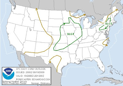
Now before I get to the snow I want to make sure people know about the severe weather possibilities. I’m starting to get pretty concerned about a mini tornado outbreak across portions of eastern Texas. By Wednesday evening the low really starts to strengthen and winds really start to pick up and turn with height. The area of concern will be from I-35 in Texas from Dallas to San Antonio eastward. The potential will continue overnight into southwestern Arkansas and into Louisiana. This will continues Thursday across the Mississippi Valley with the threat of Damaging winds and isolated Tornadoes. Here is the latest SPC outlook for Wednesday.


As the upper level low matures the cold air will really start to filter in behind the storm by Wednesday night. It will change the wrap around moisture into moderate to occasionally heavy snow across portions of Western Oklahoma into parts of Kansas. This will continue to drift north and slowly east into Kansas, Iowa, Eastern Nebraska and far Northwest Missouri by Christmas eve evening. The swath of the heaviest snows will likely run from Northwest Oklahoma to western Kansas to central and eastern Nebraska and a good portion of Iowa. Parts of Kansas, Iowa and Nebraska will likely have over a of foot of wind blown snow. As temperatures fall into the teens with wind chills to near zero.

I’ll have more on this over the next couple of days as this is a big time winter storm. As it will affect flights and driving conditions across a good portion of the country during the Christmas. If this wasn’t enough you should see what I have in the cards for New Year’s week. From California to Carolina could be seeing snow as southern mauler could be in the works. Right before the coldest Arctic air enough that make penguins shiver moves in the first 10 days of the year 2010.


Good night- Justin

Friday, December 18, 2009

Two Major Winter Storms On The Way....Hello Winter!

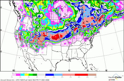
A nasty storm continues to crank up on this Friday afternoon in parts of the Southeast. This low pressure will continue to phase with the northern branch of the jet stream and deepen. Later on this evening the low pressure will be positioned off the South Carolina coast. Heavy snows will start to spread north into parts of Mid-Atlantic where snowfall rates will increase to near 1 to 2 inches per hour. These heavy snows will to continue to strengthen in bands with snowfall amounts up to 3 inches per hour possible by Saturday morning. As the low I believe will take a more northerly track compared to the model consensus of northeast. This will take place in my forecast once it hits the Cape off North Carolina and encounters the warm Gulf Stream. This will really wind up the storm and with centrifugal force allow the low pressure to drift north. Then as the storm starts to interact with some cooler water and max out. The storm will then turn right and drift northeast to follow the warmer waters of the Gulf Stream. This will likely be a crippling storm for parts of the I-95 corridor. A large swath of 10-16 inches of snow will stretch from Ashville, North Carolina north to Washington D.C. to Baltimore and Philly Then up NYC and Boston. Now this will be difficult to pinpoint at this point but I can see some parts of Virginia to New Jersey getting over 20 inches. As I expect an intense band of snow to form just to the northwest of the low pressure. As I'll be not surprised with the dynamics and character of the low pressure to have a partly cloudy skies right under the low pressure. So now we have talked about the snow potential what about wind and beach erosion. Winds will be pretty steady within the heavy snow band 20-30mph with some higher gust. Then as you get closer to the coast of N.C. up north to New Jersey I can see winds 30-40mph with gusts up to 60mph. This will likely cause some moderate beach erosion in these areas with lots of power outages. This is a major storm system in a very populated area but thankfully not a large expanding slow moving storm system. Here is the latest snowfall amount from one of the computer models.


If this wasn’t enough an even bigger and more widespread winter storm looks likely to develop by Christmas. Right now the models are having a hard time figuring out which path it will take, how strong it will be and how much cold air will be to the north of the low pressure. So I won’t use any of the model data but I will explain here briefly what I see happening next week. First off the GFS computer model and main model used for forecasts you see is absolutely awful right now with its forecast. Several things after a closer look don’t make much since with it’s handling of convection to height falls to handling Alberta Clipper ahead of the main energy coming out of the Pacific Northwest. So it wants to feedback and placing more energy ahead of the shortwave. This will pump way to much warm air in front of the developing low and makes the storm track way to far north. Looking at the ensembles and thinking back to previous scenarios I believe there is a chance of a low pressure developing and moving northeast into the Chicago area. I don’t believe that as some of the computer runs have been saying that the low develops across Kansas and races northeast into parts of Iowa. The cold air coming south behind the storm system and also the cold air laid down by the Alberta clipper a couple days earlier. Will not allow this to happen and will likely press the Baroclinic zone much further south. As we’ll likely see a nice pressing of the cold air and see a low pressure form across Oklahoma or even North Texas. The next tricky part and the ensembles or collection of models has two scenarios which I see to be legit. #1 the storm strengthens quickly across the Central and Southern Plains and moves northeast into Missouri and eventually into the Great Lakes as it weakens. As another low and ultimately the main low develops across the Southeast then really gets going as it deepens up the East Coast. #2 track and scenario is that the cold air presses south into the Southern Plains and weaker low presses east across Texas with a trough extending north into Missouri. As the main low gets going across parts of East Texas or Louisiana and deepens across the South. Then it would turn northeast as another major blizzard for the Mid-Atlantic and Northeast.


Timing is the key to this storm as if the cold air presses east of the Rockies the storm track will be much further south and pressed eastward. The models will continue to pick up on the next storm system as it begins to understand the effects from storm #1. So don’t jump on the northward track and storm track west of Chicago. As I know the talk from here across parts of Oklahoma to my home state of Indiana to even parts of the Tennessee valley. That was getting excited for a possible white Christmas has all but stopped and given up. Don’t let your guard down people from Oklahoma to Tennessee to North Carolina and points north. This pattern is still there to produce a very large and disruptive winter storm from Wednesday to Saturday of this coming week. So don’t return those sleds you may have bought for the kids or yourself. =) Winter has arrived and it’s here to stay for a while.


Have a great weekend everyone!! Justin

Wednesday, December 16, 2009

Major Christmas Storm Looking More and More Likely


A very impressive pattern setting up that I have been tracking and talked about for the past month and a half. This pattern that I alluded to at the beginning of November is starting to set up as we head towards winter. So it only figures as we head into officially the winter season nature snow guns will be full blown. We tried to get into this pattern at the start of December but the seasonal changes weren't quite ready. No stopping it this time as the global weather pattern is really something we haven't seen across the lower 48 states in years. Which means for the Lower 48 is a very active and a strong cold trough in the east in later half of December that will retrograde into January.

Now later this week the first of three storms will cross the US in the next 10-12 days. Two storms in the run up before Christmas, including one around Christmas Day. The idea of the nation's most widespread white Christmas since 2002. The modeling (GFS) is pulling its trending west and is still having its feedback problems. So instead of the storm moving east and continuing right off the Carolina coast. I believe there will be a lot of 1-3 inch amts are likely from Missouri to the Mid-Atlantic States. With a heavier snows from interior Carolina to the Delmarva with a 3-6 inch swath into the weekend

At the least, a lot of 1-3inch amounts are likely from Missouri to the mid-Atlantic states with number one with heavier snow in the interior Carolinas to the Delmarva, with the possibility of amounts of 3-6 inches or more on the weekend all the way back to the big cities from DC to NYC and BOS with heavier amounts southeast of that. I expect to see the trend now starting from nothing two days ago from South Carolina northward to a full quick moving moderate size snowstorm up the coast.

Then next is Christmas week and the possible crimpling Christmas storm. First starting into the Pacific Northwest then diving southeast quickly with the Arctic front. These will then join up with the southern jet stream and develop a low pressure across Texas. This will help to produce snow, sleet and freezing rain to the north and heavy rains to the south. Right now I believe heavy snows are possible from the Southern Plains east to Ohio and Tennessee Valleys then northeast into the Mid-Atlantic. As by December 26th there will likely be a lot of the country under snow.

If this wasn't enough another storm will likely move just to the south of the previous storm track. As money in the bank scenario looks to take shape just before New Years. As the trough and polar vortex shifts west and stregthens the southern jet. Energy in the southwest comes out and snow could fall pretty far south with the newest addition of cold air by the year 2010.....Below is the current snow cover across the United States.

Sunday, December 6, 2009

Major Winter Storm Still Expected

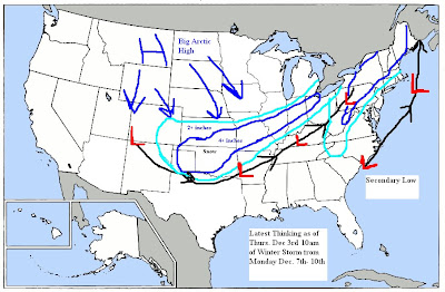
As mentioned over a month ago and have been talked about several times over the last week. A major blizzard is in the works but may be a little further north then I expected it to be. The missed forecast by me is because of the very strong high pressure in Canada being a little further north. So what this is doing or not doing I should say is dropping the front further south with a push of cold air. So the low pressure will likely come out of Colorado and ride the front/baroclinic zone east then northeast. There is a very strong jet stream with this system and besides the heavy snows there will likely be winds over 60mph in spots. Here is a couple graphics to show the path and the latest snowfall map by the GFS. I still think there is time to adjust the storm track a little further south. So the track of the low pressure from far northeast New Mexico east to far Northeast Oklahoma to Southwest Illinois(near St. Louis) northeast into Lower Michigan near Detroit.  What I still expect and has been forecasted is another low pressure to bomb out off the Northeast coast. Probably developing just off the North Carolina coast then hugging the coast as it deepens to the notheast.

Thursday, December 3, 2009

Latest Thinking of First Significant Winter Storm Next Week

Good Thursday Morning:
The model can't handle the Western trough. The new 114 off the 6z, though farther east and weaker than the Calorevada bomb it had, is still wrong. Instead, the UKMET and Euro are in much better shape, as they do not overdo the cold air feedback over the Rockies that deepens this too much. Instead, they send a piece of it out through the Plains Sunday and through the Northeast Monday, driving the arctic boundary back to Texas and pushing cold air east through the Ohio Valley and Northeast. The escape of the energy, plus the colder boundary conditions, force the wave to develop over Texas.
In addition, the weaker Western system is flatter until it bombs out near the East Coast. So, no low cutting to the Great Lakes, but instead a storm running east-northeast out of Texas to near Huntington, W.Va. with a swath of heavy snows from the Texas Panhandle through much of the Midwest, and then north of the Mason-Dixon Line to interior southern New England. This storm should turn to rain on the coast, but the GFS is missing the boat, in my opinion, on the energy that comes out in front (1) the cold air that comes behind that (2) and the track of the storm, farther south (3) before it bombs out. This will be a major winter event, with beat-the-numbers cold behind it south through Texas, and then to the East Coast. My take is that the negative AO and NAO are taking over, and it's time to start taking this into account when looking at the modeling......Especially the GFS with it's nortorious feedback problems during El Nino years and the Western Ridge and split flow.

Afternoon Update: 2pm
Here is my latest thinking of snowfall and storm track from next Monday-Thursday. As this storm will have very cold air spilling down the Plains behind it. More on this to come as the models continue to come around to what the pattern is setup for. True Arctic air is no match for the warm air to the south and the models continue to not see this. There will be a some precip and snowfall across the Central Plains and Ohio Valley Monday into Tuesday prior to the main storm system.


Latest 18z GFS is starting to come on board now but we'll really start to understand the storm when it gets within 90 hrs.  Here is the map for Tuesday Eve at 7pm. Notice the Low pressure centered in Western Oklahoma about 100 miles further north then I'm expecting it. I also think the GFS is strengthening it too fast as it won't really start to deepen until it gets to Northern Texas then start moving northeast.


November one of the warmest on record

November ends as one of the warmest in over the last 10 years. Will December be just as cold as November was warm?

Wednesday, December 2, 2009

GFS & Other Computer Models continue to underestimate the cold dense air

Don't believe the GFS beyond 3 days in this pattern. The cold air wins early next week and temperatures now forecasted will likely be around 25 degrees colder. As mentioned a month ago I thought the pattern would create a good chance of accumulating snow the first 10 days of December. In my opinion snow is still very possible for Texoma next Tuesday and Wednesday. Currently the GFS and other models have been going back in forth for a possible winter storm coming out in the Southern Plains early next week. Right now i'll use the most popular model the GFS that a lot of the forecast you see come from. The latest and the last previous model runs have the Arctic front that is coming south this week. From Colorado east to parts of Kansas some where between I-70 and I-40. I believe this new shot of true Arctic air will be much more powerful and drive the front much further south. So far south I can see the front down by I-20 as a wave of low pressure from the West move along it Tuesday and Wednesday. Right now the phasing and other parameters will likely not let this crank up. However will be a pretty nice wave of low pressure that will move east northeast across the nation. Accumulating snow and some ice will break out across Oklahoma and Texas Tuesday and Wednesday. It's too early to speculate on amounts but this situation could produce significant accumulations for portions of the area. Behind the storm system the new Arctic air and new snow cover will likely set the stage for single digit low temperatures possibly across the Texas Panhandle, Kansas and Oklahoma. Looking further east the cold and snowy pattern will continue and will likely intensify by the second and third week in December. Here is the 12z GFS look at Tuesday afternoon in which you can see the blue line(snow line) well off to the north. I believe the cold air moves the front much further south at this time like mentioned earlier.


Models will trend colder and snowier for Oklahoma and North Texas. This also includes for places to the East as the cold weather is here to stay for a while.  Looking ahead for the next 10-14 days you can see it's looking awfully cold and very active so grab those snow shovels you Eastern Snow Geese. =)

Wednesday, November 25, 2009

Winter is on the way...December coldest since the year 2000

Here comes the cold air as December from the Rockies to the East Coast looks very cold. As the Ohio Valley and Great lakes could be the coldest since the year 2000. With an active southern track that will likely produce accumulating snow by the end of the year. In such places as Abliene, Texas to Dallas to Shreveport, La to Birmingham, Al to Atlanta, Ga. The Arctic air arrives late next week with a possible winter storm from Texas to the East Coast.


Tuesday, October 27, 2009

Major Storm System To Produce Severe Weather and Heavy Snow

Major storm system will develop across the Intermountain West and move into the Plains Wednesday-Friday. This storm will dump very heavy snow across the Rocky Mountains with Denver getting close to a foot in a half of snow by Thursday night. Here is the latest NAM 12Z model showing predicted snowfall accumulation by Thursday Evening.

Another big event of this storm system will be severe weather. This will start to become a threat by tomorrow evening(Wednesday evening) however it may take till overnight into Thursday morning before really getting going. A very strong jetstream will dive into the Southwest then eject out into the Plains by Thursday. This will create very strong sheared environment first across Oklahoma and Texas Wednesday night then expand northeast Thursday and Friday. Severe weather with a threat of tornadoes and Wind damage will develop and spread across Okahoma and Texas. Then Thursday and Friday east into Missouri, Arkansas, Louisans, Illinois, Indiana, Ohio, Kentucky, Tennessee, Alabama and Mississippi. As the low pressure forms over northeast New Mexico and races northeast into Northern Minnesota by Friday. Here is the latest SPC outlooks for Wednesday night and on Thursday.   -Justin-


Sunday, October 25, 2009

Looking Ahead To This Week And Into November

Pattern has slowed down a little and I have been a little busy so I haven't posted that much lately. However don't worry I have been still watching the weather and been trying to find time to continue to put together the winter forecast.

The coldest October in Denver history was 1969 with 2002 ranked 3rd. Right now, the month is 7.5 below normal (through today) But another week of double digit below normal cold is shaping up, with a snowstorm likely later in the week this should have them finish between 8 and 9 below normal.. not as cold as 1969, but near or lower than 02. Denver Coldest Octobers

A couple interesting storm systems this week as the first one is developing right over top of me here in Oklahoma. Then the second coming up mid week that the models still having several different scenarios. Now looking ahead to the next week and the next month. So  lets play the typhoon game again!

Lupit is recurving now so punch the 6-10 day clock of the trough coming through the east with a 5 day period of below normal temps.

Latest Ensemble Run
Here is the latest Ensembles that shows one more shot of some cold air into the Central Plains then into the East by months end. Then I do believe at the start of November the cold will ease and retreat north. However will build across Canada and will set the stage to plumnet into the deep freeze. The latest ensemble run really shows the cold air that will likely build across Canada as we go into November. Looking at previous analogs years that match to this years October. The damn could break right before Thanksgiving or could wait for the Winter Soltice. I guess we'll have to wait and see


Sunday, October 11, 2009

Major Storm System from Coast to Coast this Week

Winter getting a jump start


Des Moines received its earliest 1 inch snowfall on record yesterday when 1.1 inches feel and two inches of snow in Denver forced the cancellation of the Rockies-Phillies NLDS playoff game last night. A major snowstorm blasted Nebraska Friday night into Saturday as nearly 14 inches fell at North Platte with over 17 inches in some isolated areas. Wind chills dropped to 11 degrees in Rapid City, South Dakota. More snow is expected into Monday with winter storms watches now posted from Montana to Minnesota. This will be the weaker of two storms this upcoming week.

Models are coming together in agreement of how the storm system talked about in the previous post will come into the U.S. Still plenty of details let to iron out on how it will tranverse the Plains and into the East. However all signs are pointing to a major storm system with plenty of snow for October north of the track.

The teleconnection that I talked about in the previous post with typhoon recurving is setting up near perfectly. Normally, the typhoon recurving simply outlines the ridges and how it pumps the ride west of the date line. This then continues to the east and pumps a deep trough in the Gulf of Alaska, which pumps the western Ridge. So if you have a strong ridge in the west this forces a trough to dig into the East. So it's not the typhoon, but what it means is the useful tool. However in this situation the actual tropical energy aka moisture could actually get involved. As typhoon Melor was absorbed into a extra tropical low and is still very well intact as it crosses the Pacific.

I believe this will first hit the Pacific Northwest with lots of wind, rain and heavy mountain snow early this week. Then as the energy crosses the Rockies the low energy transfers to a baroclinic zone. That is put down from a weaker low that will cause heavy rains in the Southern Plains into the Mississippi Valley early Monday and Tuesday. The front will then become stationary and wait for the main energy that will help develop a strong low pressure by late week. This low pressure will likely form in Oklahoma on Wednesday then quickly move east across the middle Mississppi Valley by Thursday and Friday. Then as the northern Jet and southern jet fully phase the trough will become negatively tilted. Helping the low pressure to turn northward and deepen as it heads into the Northeast.


This will likely cause some more flooding rains in the south and also the possibility of severe weather. The flip side of the front will be producing cold rains changing over to snow. As a swath of accumulating snow will streak east out of Nebraska into Iowa, Wisconsin and even Northern Illinois. Chicago looks right on the border line as it looks now. Still really early to start pinpointing amounts or the actual snow/rain line. This snow will likely continue into Michigan and really start to become heavy from Pennslyvania into the interior Northeast. This will likely be a tree striper as lots of leaves still remain on the trees. As the snow will likely be very wet and cling to everything with a strong north wind as the storm winds down. Beyond this storm very cold air for this time of the year will surge south. As rain changes to flurries possibly as far south as parts of Tennessee with frost and freeze possible down to Alabama, Mississippi and Georgia By the weekend.
This is my latest forecast as in what I see happening this week.


Stay tuned as this storm starts to develop and I will no doubt have to adjust my forecast. -Justin-

Saturday, October 10, 2009

Big Storm and Trough Next weekend in the East?


 Temperatures are starting to really cool down across Canada as the nights are getting longer and the snow cover is starting to grow. These temperatures will across the Northern and Central Plains for the weekend with accumulating snow in Colorado, Nebraska, Kansas and South Dakota. This resevior of cold air will make its way south and east later next week.


One of my favorite teleconnection this time of the year is recurving typhoons in the western Pacific near Japan. The rule is if you see a Typhoon recurve to the east of Japan then expect a Trough to develop in the east coast of the United States within 6-10 days. Well there was a typhoon that curved just to the east of Japan late this week. So 6-10 days later would be Wednesday- Sunday of next week. Models are starting to advertise this trough and low pressure development.  Details are still vague but the potential in my eyes is there for a pretty decent fall storm system.  That will likely development in the Southern Plains along a front and then the area of low pressure will deepen tracking northeast into the Tennessee and Ohio Valley.  Causing lots of rainfall in the places that don't need it and the possibility of severe weather. Then as the trough deepens it will pull in some below normal temperatures changing rain to snow. As I see a possible snow in the upper Midwest and into the interior Northeast. Then with the trough digging into the east I can see the first snow flurries by the weekend as far south as Lexington, Kentucky and Washington D.C.
Stay tuned as just like was advertised a month ago that October was looking very active.
Have a great weekend everyone!! -Justin-

Wednesday, October 7, 2009

Heavy Rains & Severe Wx before Polar Plunge


A storm system now centered off the California coast will begin moving east. Once it taps the increasing moisture, rain and thunderstorms will envelop the southern Plains again, beginning later today and continuing through Thursday night before ending Friday. Heavy rainfall will be possible, especially over eastern Oklahoma into parts of Missouri and Arkansas. There is also the possiblty severe weather Thursday afternoon into Thursday night. While all this is going on, cold air will build over western Canada. The cold air will begin moving into the southern Plains by Friday and will continue pouring south over the weekend.  More on the Polar plunge later as i'm a little busy today......Justin

Tuesday, October 6, 2009

Denver Weekend Snow followed Major Cold Wave for October


Map for High Temperatures this
Coming Monday ( Columbus Day). As a large Candian area of high pressure moves south into the Central Plains. Before this will be a major storm system with heavy flooding rains, Severe T'storms and the possibility of some accumulating snow. Tracking from the foothills of Colorado through parts of Kansas and Nebraska. I'll have more on this tomorrow.....Justin

Tuesday, September 29, 2009

First Fall Severe Weather Outbreak Wednesday and Thursday

Here are some maps to show you the threat for severe weather. Starting Wednesday afternoon and continuing into Friday morning. I'll have more details on the timing of event tomorrow afternoon.


Sunday, September 27, 2009

Fall Severe Wx Season Starts Later this Week

Our active weather pattern that I have been alluding to kicks in later this week. As it still looks like the next 10-14 days will be very active. As several troughs with pressing cold air try to work itself south against the waning summer heat. This will provide places in the northern Rockies and Plains with their first snowfall. The greatest impact most likely will be a couple possible significant fall season severe weather outbreaks. The first one will likely take place on Thursday afternoon and evening. Here is a graphic that sums up the scenario for the central and southern Plains. Still over 4 days away so a lot of things can change but I'll have more detailed forecast in the next couple of days. Thursday could be a chase day for me as I have been dealing with serious withdrawal symptoms from a long summer.

Friday, September 25, 2009

Below Normal Summer Temperatures

Looking at the 90 day temperature means you can see during the Summer months June, July and August. A good portion of the nation had below normal temperatures. Much below normal temperatures in the North and Central Plains and including the upper Mississippi Valley. Above normal temperatures were in a couple locations such a California and parts of New Mexico and Texas. Then the graphic next to the temperatures shows the 3 month precipitation compared to normal. You can see the places that had below normal precipitation matched up with places with higher than normal temperatures. This is easily visible across the drought stricken areas of south Texas.

Thursday, September 24, 2009

Stormy Start to October?

My ideas of a stormy start to October continue to be support by teleconnections, ensembles and now some of the medium range models. Here is a look at the latest 8-14 500mb analog composite. With this kind of pattern I can see some pretty nice size severe weather outbreaks for fall standards across the Plains and into the Ohio and Mississippi Valley.

Wednesday, September 23, 2009

Temperatures So Far This Month

This is what a split flow in the jet stream does at the end of Summer. Cool underneath and warm over top. As several upper level lows have been affecting the South where near record warmth has occurred in Big Sky Country. Here is a graphic that shows temperatures compared to normal for the first 21 days of the month.

Tuesday, September 22, 2009

Quick Post on Winter Forecast ideas

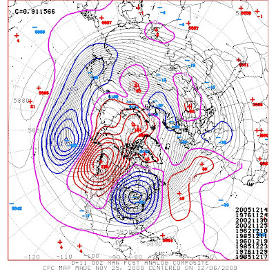
Quick post here showing that the atmosphere is starting to show signs and clues of its winter Pattern. Here is the latest 8-14 Analog composite of the 500mb flow center on October 3rd. Notice the reds in Canada representing ridging aloft or warmer than normal heights. As the height lines indicating the flow moving from a ridge off the West Coast. To a fast west to east flow across the lower 48 with lower than average heights. This indicates an active jet stream under an area with higher heights helping to develop high pressures across Canada. So Cold areas of high pressure in Canada with an active jet stream underneath. Hmm can you see what clues i'm pointing out and what kinda of winter we might being headed to?
Looking at the latest ensembles I believe October will come in like a lion. Stormy weather with possible severe weather and heavy rains will set up from the Southern Plains and into the Mississippi, Ohio Valley. As the Northern Rockies get their first cold shot of air with first significant snowfall. As you can see a nice jet indicated by the packed height lines in the above graphic. As NAO looks to be tanking in the negative side by around the 7th of October indicating a trough in the East. PNA looks to be near neutral for the time period so a firehouse jet might come into the West. This is really good as they need the cool down and rainfall to increase to damper the fire threat. AO index looks to go negative then strong positive then strongly negative. This would be an good indication that there will be a good source of some cross Polar air from Siberia. High temperatures currently are in the 20s and 30s with lows in the teens. However have been drastically decreasing over the couple of weeks. So all together winter is preparing itself but we still have a good month or so. The United States really don't start seeing snow storms outside the higher elevations till after Halloween.

Thanks for reading and please leave your comments on my guest book.
Justin

Monday, September 21, 2009

Cut-Off Low instead of Big Trough

As we head into the work week another very strong upper level low will dig into the central and Northern Plains. So my forecast last week was not all together correct as I failed to see the stronger ridge in the east. So we're heading into another split flow where a piece of energy gets stuck underneath the main jet stream. Here is the latest forecasted 500mb level for the exact time I showed you in the last post.
You can notice the lack of support from the northern jet by the time we get into tomorrow evening. This will leave the upper level low to stall and spin across portions of the Central Plains. This will first cause a strong cold front to plow south into the warm and moist air over the Southern Plains. So severe weather is a possibility for portions of Texas, Oklahoma and western Arkansas today. Here is the latest outlook from the SPC.

Temperatures will plunge behind this front to below normal high for several days. I'll have another update on how cool temperatures will be this week here later this afternoon. Plus take a look as I might be just a week off from the Cold Canadian push of air down into the East.

Wednesday, September 16, 2009

Change in Wx pattern brings Chaos to the Wx Models

Oh GFS and your lovely pros and cons...Here is a quick run down of how I think things will play out early next week.

Typical GFS fashion with its horrible feedback issues at times. Let me show you here with two graphics which indicate the same time period. However the first one was created during the 0z run Tuesday evening and the second one is only 6 hours later from the 6z run. Notice any difference to the 500mb patter and heights? Ya you can say huge difference as the first run has low 60s and breezy in St. Louis. While 6 hours later its says its probably sunny and in the upper 70s.


Now when I say feedback issues this is what I mean. Models sometime have a hard time trying to determine the production and how to transfer latent heat in the atmosphere. Well on this example you can see in the 0z a very powerful trough digging south with a strong vorticity max in front of the trough. The 6z model still has the energy by splits it into two separate energy bundles. One across the four corners and another piece connected with the trough in Canada. You'll see a lot of this this winter as we'll likely have a stronger than average southern jet and the Polar jet diving southeast trying to merge. As there will likely be a split flow in the west with the two jet streams merging across the Central and East.

In this example and why I have hinted at the pretty strong outbreak of cooler than normal temperatures next week and into the following weekend. The models see it but it just doesn't know how to handle it. So instead of the energy being bundled ahead of the trough in the Ohio Valley. The energy will be back a little farther west and stretched a little more west to east. As the trough will want to dive south toward Oklahoma, Arkansas, Louisiana area. As compared to the 0z where the trough axis will head toward Georgia and the southeast states.

So expect places like Northern and Central Plains to see their pinpoint forecast that the NWS uses to vary a lot over the next couple of days. Typically the GFS figures these kinds of issues out about 2-4 days prior to the event. I believe the Northern Plains will see their end to the growing season by next week. This colder air will filter into the Great Lakes and into the Ohio Valley. Overnight lows will probably dip down to near or below freezing north of I-80 (Dakotas, Minnesota, Wisconsin). As temperatures in the 40s will be common elsewhere. Right now MOS numbers for Indianapolis for Wednesday morning is 61 Thursday morning 58. I will go with both mornings around the 44 to 47 degree range.

High temperatures down in my area by next Tuesday and Wednesday will be in the Lower to middle 70s. MOS temperature prediction has a high temperatures in Lawton on Tuesday and Wednesday of 87 degrees.

So we'll see if I'm correct or if the model is correct on our first big push of cold air from the northern reaches of Canada.

Alright time to get some sleep... Justin

Saturday, September 12, 2009

Summer heat is coming to a end....

Heavy rains across Texas and the Southern Plains marks the end of the summer heat. As the weather pattern is changing and will completely change in the next 2-3 weeks. Until then we'll continue with the summer pattern but a tempered one.
Flooding rains are on going here in Texas and across the I-35 corridor in Texas. As some locations have received up to 11 inches of rain which has caused some flooding. The upper level low has pretty much stalled out and will slowly weaken over the next 3 days. So expect the rain to continue across the Southern Plains and Southeast.

This also has pretty big affects on the winter in these locations. Which also supports my winter prediction mentioned a couple months ago. That the south tier of the nation will be cooler and wetter then average this winter. As I'm continuing to study and fine tune my winter forecast.

Have a great weekend everyone!

Wednesday, August 19, 2009

Tropical & Severe Weather Update

First lets talk about the tropics as hurricane Bill continues to be a powerful storm. Now a Cat 4 hurricane with 135mph sustained winds. WNW movement has continued by as you see below the models and the NHC continue to predict a northward turn. I'm still very worried for the Northeast coast Sunday and Monday. As any job to the west from the storm will put them in Hurricane force winds. That includes the city of Boston that is looking at a lot of rain from a frontal boundary. Then as Bill gets closer increasing winds and rain, how much that is still to be seen. Ana is no more and any life to her yesterday was sheared apart by the upper level low. Still lots of heat energy in the Gulf of Mexico with improving upper level conditions for now. However the upper levels become more southwest as the trough now across the Northern Plains swings to the south. Still watching closely but at this time it looks like I was wrong about redevelopment in the Gulf.


Now to a more current issue across the lower 48 states is severe weather. Currently one tornado watch posted but another one may be posted soon across parts of Oklahoma. Here is the latest SPC outlook for severe weather for this evening. Two main areas of concern are across Illinois with a broken line of severe t'storms. The second hot spot is from southwest Oklahoma north to southern parts of Kansas. This area will likely light up with severe t'storms some being super cells capable of producing large hail and a isolated tornado.
As you can see the Severe threat continues tomorrow into the Ohio Vallery and southern Mississippi Valley. Main threat will be more damaging winds and some hail then tornadoes.

Strong cold front and trough continues to surge its way south. As much cooler and drier weather takes over from the Plains east to the East Coast by early next week. So if you live especially along and east of the Mississippi river. Prepare yourself for some cool nights and mild to warm afternoons.


Tuesday, August 18, 2009

Quick Tropical Update-Ana and Bill

Bill continues to turn its way across the Atlantic currently affecting no one right now. Here is the latest list of computer runs over the next several days.

The track takes it northwest over the next 24 to 48hrs then north west of Bermuda and east of the United States. It's currently a Cat 2 Hurricane with 105 sustained winds. This is forecasted to become a Cat 3 and maybe a weak Cat 4 in the next 48 to 72 hours. So Hurricane Bill will likely become the first major hurricane of the Atlantic hurricane season. This intensity with such a warm core will fight off the trough as it slides into the weakness across the Atlantic. So its bares watching on whether the trough makes Bill turn north or just northwest. If it doesn't turn north by 70 west then look out New England!
Now for more of a immediate threat to the U.S. is what was previously tropical storm Ana. I don't understand why the NHC is downplaying the remains of Ana. The map below is from the National Hurricane Center. The yellow hatched area over eastern Cuba is for low probability. In which they say regeneration is unlikely over the next 48 hours.

Ya the circulation pretty much vanished yesterday but the wave with thunderstorms is still there. The heat energy is still there just spread out and to make it even more interesting its negatively tilted. Now this is why I think there is a 2 to 3 chance of this becoming at least a minimal tropical storm. Currently a upper level low is anchored just to the southwest of the remains northeast of Cuba. Over the next 24 hours this upper low will continue to ventilate t'storms as a upper level ridge sits to the north. By Thursday afternoon the remains will be in the southeast Gulf of Mexico. The upper level low will then weaken and be moving away from the remains. This will allow the southern side of the t'storms to begin developing around the low. Looking at the upper levels according to the models, an upper level ridge will strengthen right over top. This is when I believe Ana comes back to life with a fast development to tropical storm strength. Now going beyond that I'll wait to see if things start developing and lining up. I will say that the Gulf is primed for quick development and a storm to become an hurricane within 36 hours. Something to definitely watch over the next 48-72 hours in the Gulf of Mexico.