Monday, May 23, 2011

Significant Severe Weather Likely Over Next Two Days!

 Today might be just a tease of what could happen if the models play out tomorrow afternoon across the Great Plains. I'll be out chasing today across sw Oklahoma and maybe far north Texas. Tomorrow the dryline presses east and I'll be chasing across central Oklahoma. Where tornadoes look likely with any supercell that develops.

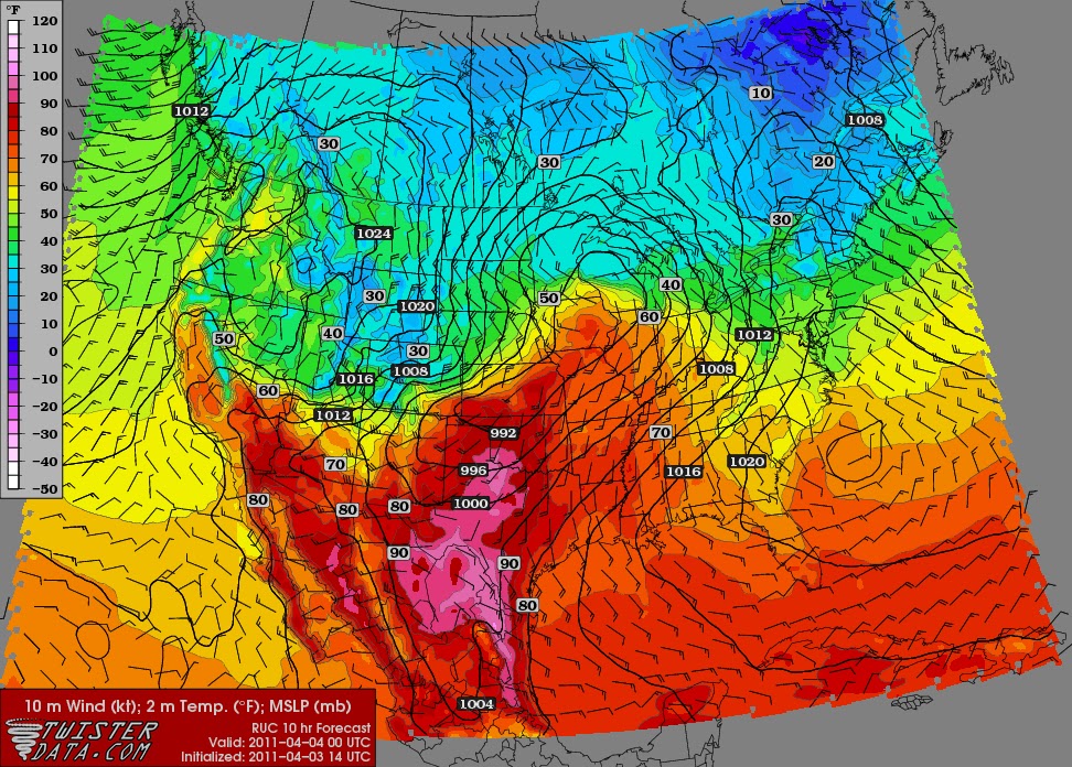
Today the tornado threat is lower but still nothing to take lightly with a very unstable atmosphere. Many of the storms will be capable of producing very large hail up to softball. Tornado will most likely occur with discrete supercells that can turn right. Greatest risk of tornadoes comes in two areas I believe, One across NE OK near Tulsa and another one around Lawton & Wichita Falls by late afternoon.

Don't forget to check out my live streaming video through this afternoon and evening.

Tuesday, May 17, 2011

Long Time No Post

Ya I've been a big slacker on this website in posting new blogs. Just haven't really needed too and been busy doing other things. Plus the severe to exceptional drought here in the southern Plains really hasn't made me post much. Currently for 2011 I have only been out in the field chasing twice & one was a blue sky bust. I'll have the summary on my second chase of the year on here by Thursday. I have it half way done but need to add a couple more things.

Things are definitely looking better for chase opportunities here by late week and into next week. Here is the link to the Storm Prediction Center for all the latest severe weather outlooks. Storm Prediction Center

If this wasn't enough excitement...haha   My Chasecation will be from June 2nd-June8th with my good friend Meteorologist Chris Stumpf. I'll have a daily forecast post then chase summary that night or next morning with pictures & video. Really looking forward to getting out in the Plains & not being tied down to my stations viewing area.

Have a great evening! Justin

Tuesday, May 10, 2011

Chase #3 of The Year Looks Interesting for Tomorrow

After a quieter day than anticipated tomorrow looks like it definitely has the possibility of being a very active one. Currently the SPC has a good portion of Oklahoma under a slight risk with a smaller area under a moderate risk.
The only thing I will say about the SPC outlook and graphic below from the NWS in OKC is that the dryline will likely be further west.
Models did a lousy job on the placement of the dryline today and typically are a little fast on movement. So I expect Super cells to develop by 4pm in western Oklahoma along 183 from Clinton south to Frederick. These storms will evolve and mature as they cross into central Oklahoma by early evening. Very large hail looks to be the biggest threat up 3 inches in diameter but a few tornadoes do look likely. More details tomorrow but wanted to put down and couple thoughts here before bed.

Monday, April 18, 2011

Wet & active pattern starts to shift west

While the Southern Plains continues to bake & burn in the midst of a severe drought. Relief could be on the way here in the next 5 to 10 days. Which is much needed looking at the latest drought index.

Parts of Oklahoma and Texas have had less than one inch of rain since the middle October. This is the driest it's been for the months of December-March since 1921. While parts of the Ohio, Tennessee and Mississippi Valleys have been very wet & active. Signs of this pattern shifting a little west have popped up on the models for the past two weeks but have yet to materialize. This is now changing and in motion with rain looking more likely and possibly widespread by late week. Here is the latest 5 day QPF outlook from HPC.
Now another aspect of this pattern change and more active weather here in the Southern Plains is the chance of severe weather. Right now many possibilities exist in the models as to where the fronts, troughs & low pressure end up. So I'm going to wait for another post to get into details on that aspect. Currently it looks like Thursday and Sunday could be very active days with regards to severe weather. So finally we might see rain and chasers here in the Southern Plains will get to play a little. 

Friday, April 8, 2011

First Chase of the Year only hours away

Slight chance of an isolated severe t'storm still exist close to home this afternoon. So with plenty of instability, weak CAP and dryline for a trigger. I plan on being out by 4pm central time chasing what I hope is a nice big supercell.  Don't forget you can watch my streaming video here on this website just click on Live Cams on the top.

Currently SPC doesn't have any area near SW Oklahoma under a risk of severe weather. As they focusing on the warm front extending from far northern Oklahoma to Kentucky. They have noted there could be a storm down the dryline but didn't mention in slight risk because of the small chance of initiation.

Don't forget to add me on Twitter for Chase updates- Twitter-Chasingthemeso

Should be leaving the station around 3pm so the chase cam will be up shortly after that.

Sunday, April 3, 2011

Severe Weather & Extreme Heat

Spring has been fairly slow in regards to severe weather but that could be changing over the next week or two. As the pesky cold air and trough in the east is showing signs of breaking down with the mean trough developing into the west. This is supported by the NAO going positive and the PNA going negative forecasted by the models. So tonight's into Monday severe weather event could be the start of more frequent bouts of severe weather from the Plains into the east.


Today looks to be a very warm to hot day across the Plains as south winds continue to surge moisture north. This will interact with a sharp cold front that will quickly dive east/southeast tonight into tomorrow. The limiting factor of today's severe weather will be a warm layer of air aloft above the surface called a CAP. Looking at the soundings this morning, it is very likely there will be very little convection prior 0z (7pm) from Kansas south to Texas along the dryline. Storms will likely start to form from Iowa to Kansas after 7pm as the cold front catches up to the dryline as the linear forcing can lift the air over the cap.

   Hot Temperatures!! Areas in pink are over 90 degrees on April 3rd!

Now even the cap will most likely inhibit storm develop during the day. The situation is definitely not something to ignore due to the explosive environment from Iowa to Oklahoma. Here below is a sounding at Topeka, Kansas the shows a shotgun sounding. Meaning that if the parcel can break the CAP the air will explode upwards allowing for explosive development of t'storms.


Eventually the cold front takes over and storms will explode up from Illinois south to Texas in more of a linear fashion. This broken line of storms will have the risk of very large hail and damaging winds as it heads southeast towards the Mississippi Valley by Monday afternoon.  Here is the SPC outlooks for Today and Tomorrow.


Wednesday, March 30, 2011

No Chasing in March But Could April Start with One?

Models continue to be iffy with the timing of the upper level energy, deepth of moisture and a pretty stout cap. However with the amount CAPE, Upper level winds and a Dryline nearby. I'm watching closely Sunday afternoon for a possible isolated Supercell from southwest Ok into N. Texas. Here are some maps from the latest 18z GFS that shows a very powerful atmosphere with a nice lid but not unbreakable lid on it. Many things will change as we head into the weekend but wanted to give a heads up on what i'm watching. Could the first chase of 2011 actually happen or will I have to wait another week? We will see.....
                                                                  CAPE 0z Sunday Evening
                                                                CIN 0z Sunday Evening
                                                            Dewpoint 0z Sunday Evening
                                              Sounding 0z Sunday Evening S. of Lawton


Thursday, March 17, 2011

When will or will the storm season arrive here in the Southern Plains!?

Looking at the latest 8-14 analogs and GFS ensembles the dry conditions across the south look to continue. As the NAO continues to disrupt the overall moisture feed from the Gulf with a high pressure over it.


From the March 2011 Enso Update
"The moderate to strong La Niña conditions that were observed betweeen mid-August 2010 and early February 2011 have weakened to weak to moderate strength as of mid-March 2011. For the March-May season currently in progress, there is an approximately 75% probability for continuing La Niña conditions, and a 24% probability for returning to neutral ENSO conditions. Probabilities for La Niña conditions drop to just below 50% for the April-June season."

So where were the tornadoes in the Springs of 71', 74 & 99'?

I'll try to get the maps together here in the next day or two. Hopefully that'll give me some hope but here in the Southern Plains. We could be looking a pretty bad drought this summer with limited storms to chase this spring.

Friday, March 11, 2011

A Very Active Last 10 days of March?

Over the last couple of days the 8-14 day analog have been increasingly pointing to an active period across the Plains and into the Midwest.
So I took the top four years on the list and looked up the storm reports centered on that date. As you can see by the examples below a stormier period could be on the way.  


 Storm reports and the overall weather pattern looks to be changing to a more trough, ridge, trough. However by looking at the NAO and PNA charts below. There could be an unfavorable trough off the east coast disrupting the streamline flow from the Gulf. This is due to the NAO going negative and supporting a trough and low pressure development off the east coast. So this could actually keep the southern Plains capped with warm temperatures.
Time will tell but we're definitely in need of the rain down here in the Southern Plains. We currently have over a dozen wildfires just in the state of Oklahoma this afternoon.

Monday, March 7, 2011

Severe Weather Safety

Severe Weather
Safety Guide

Just like a fire, an earthquake or an automobile accident, a tornado is a low probability, high impact event. Chances are, you will never experience a tornado. Even if you live in the heart of tornado alley, the chances that your house will be struck by a tornado are small. However you still need to be ready just in case you hit winning lottery ticket. Your tornado safety plan is your life saver when severe weather threatens.

The severe weather safety guidelines exist because they work most of the time. Following these guidelines won't guarantee you won't be hurt or killed, but it significantly improves your chances of survival. it is important to understand what part of the year, and what time of the day, severe weather is most likely. Those should be the times when your severe weather awareness is highest, as it is when you are most likely to be adversely impacted. Bear in mind though that tornadoes and severe weather can occur at any time of the year, day or night.

Have a FAMILY DISASTER PLAN prepared including a disaster supply kit. Which would include water, clothing, blanket, First aid kit & meds, Battery powered NOAA Weather Radio, Flashlight with extra batteries, Cash and anything special for elderly or infant.
Be Prepared. . .It's Up to YOU!

Each year, many people are killed or seriously injured by tornadoes and severe thunderstorms despite advance warning. Some did not hear the warning, while others heard the warning but did not believe it would happen to them. The following preparedness information, combined with timely severe weather watches and warnings, could save your life. Once you receive a warning or observe threatening skies, YOU must make the decision to seek shelter before the storm arrives. It could be the most important decision you will ever make.

What Can Do Before Severe Weather Strikes YOU

Develop a plan for you and your family at home, work, school, and when outdoors. The American Red Cross offers planning tips on their Internet site: http://www.redcross.org/services/disaster/keepsafe/

Identify a safe place to take shelter. Information on how to build a Safe Room in your home or school is available from the Federal Emergency Management Agency at http://www.fema.gov/hazard/tornado/to_saferoom.shtm

Know the county/parish in which you live or visit. The National Weather Service issues severe weather warnings on a county. Keep a highway map nearby to follow storm movement from weather bulletins.

Have a NOAA Weather Radio with a warning alarm tone and battery back-up to receive warnings.

National Weather Service watches and warnings are also available on the Internet. Select your local National Weather Service office at http://www.weather.gov/organization.php or go to the National Weather Service Home Page at http://www.weather.gov/

Listen to radio and television for weather information.
Check the weather forecast before leaving for extended periods outdoors. Watch for signs of approaching storms.
If severe weather threatens, check on people who are elderly, very young, or physically or mentally disabled

What YOU Can Do When Threatening Weather Approaches

Lightning Safety Rules
Postpone outdoor activities if thunderstorms are imminent. This is your best way to avoid being caught in a dangerous situation.Move to a sturdy building or car. Do not take shelter in small sheds, under isolated trees, or in convertible automobiles. Stay away from tall objects such as towers, fences, telephone poles, and power lines.
If lightning is occurring and a sturdy shelter is not available, get inside a hard top automobile and keep the windows up. Avoid touching any metal. Do not take a bath or shower during a thunderstorm. Turn off air conditioners. Power surges from lightning can cause serious damage. If Caught Outdoors and No Shelter Is Nearby Find a low spot away from trees, fences, and poles. Make sure the place you pick is not subject to flooding.

If you are in the woods, take shelter under the shorter trees. If you feel your skin tingle or your hair stand on end, squat low to the ground on the balls of your feet. Place your hands over your ears and your head between your knees. Make yourself the smallest target possible and minimize your contact with the ground. DO NOT lie down.

Remember, if you can hear thunder – you are close enough to be struck by lightning!

Tornado Safety Rules
-In a home or building, move to a pre-designated shelter, such as a basement.
-If an underground shelter is not available, move to a small interior room or hallway on the lowest floor and get under a sturdy piece of furniture. Put as many walls as possible between you and the outside. Stay away from windows.
-Get out of automobiles. Do not try to outrun a tornado in your car; instead, leave it immediately for safe shelter.
-If caught outside or in a vehicle, lie flat in a nearby ditch or depression and cover your head with your hands. Be aware of flying debris. Flying debris from tornadoes causes most fatalities and injuries.
-Mobile homes, even if tied down, offer little protection from tornadoes. You should leave a mobile home and go to the lowest floor of a sturdy nearby building or a storm shelter.

Flash Flood Safety Rules
-Avoid walking, swimming, or driving in flood waters.
-Stay away from high water, storm drains, ditches, ravines, or culverts. If it is moving swiftly, even water six inches deep can knock you off your feet.
-If you come upon flood waters, stop, turn around, and go another way. Climb to higher ground.
-Do not let children play near storm drains.

Stay Informed. . .Use NOAA Weather Radio
The National Weather Service continuously broadcasts warnings and forecasts that can be received by NOAA Weather Radios, which are sold in many stores. The average range is 40 miles, depending on topography. Purchase a radio that has a battery back-up and a Specific Area Message Encoder feature, which automatically alerts you when a watch or warning is issued for your county or parish.

Check with your local National Weather Service office or visit the Internet site to determine if your county is covered by NOAA Weather Radio. National Weather Service watches and warnings are also available on the Internet by selecting your local National Weather Service office at or by going to the National Weather Service Home Page.

What to Listen For...

Tornado Watch: Tornadoes are possible in your area. Remain alert for approaching storms. Know what
counties are in the watch area by listening to NOAA Weather Radio or your local radio/television outlets

Severe Thunderstorm Watch: Tells you when and where severe thunderstorms are likely to occur. Watch the sky and stay tuned to know when warnings are issued.

Tornado Warning: A tornado has been sighted or indicated by weather radar.

Severe Thunderstorm Warning: Issued when severe weather has been reported by spotters or indicated by radar. Warnings indicate imminent danger to life and property to those in the path of the storm.

So what can you do if stuck in your home.... I have a real simple rule I tell my school kids when doing talks.
It's called the DUCK rule.

Home Safety
In the drawings below you can see simple layouts of typical homes. The area outlined in yellow are the areas that would be the safest place to be in case of a tornado.


Wednesday, March 2, 2011

Now you see....Now you don't

Well played Mother Nature...Well Played... After looking over this morning 12z models. The threat of severe weather anywhere in the southern Plains has almost vanished. Yesterday it looked amazing & today it looks like Horse sh@t. =) Very complicated jet stream out in the Pacific so changes could occur. However the chances don't look good at this time to be chasing anytime this week.

Here is the latest Day 3 SPC outlook

Tuesday, March 1, 2011

Welcome to the 2011 Spring/Storm Season!

March 1st represents the start of the meteorological Spring season (March 1st- May 31st) and in the chaser world "Storm Season".

Looking ahead to this coming Friday the 12z models have come to a mild agreement that supercells could form in western Oklahoma. Here are some the maps from the 84 hr NAM


So to celebrate the start of another storm season on the Southern Plains. I figured I would post a couple pictures of the previous storm seasons. Enjoy!


Slowly Rotating Wall Cloud- Colorado 10'

Beautiful Rainbow-Colorado 10'


Towering Cu-09'


Mothership-SW OK 08'


Mid Level Funnel- N.Tx 09'
Kansas- 10'