
Tuesday, June 15, 2010
Chasecation Over and I'm Worn Out!
Sorry for the lack of posts but the lack of sleep and me just spaced it on Saturday and Sunday morning. It was another great time with Becky and was glad that my buddy BJ got to come along as well. I'll be working on a complete day by day summary of the trip and lots of pictures to come. However this will take a good week to complete so it'll give you something to look forward too.
Friday, June 11, 2010
Day 4 Morning Briefing
Greetings from Aurora, Colorado (Far east side of Denver)
Well finally a fun day of chasing as we experienced some very nice storm structure, couple mid level funnels, quarter to golf ball size hail and a couple rugged wall clouds. Unfortunately we stayed on the first tornado warned storm too long. As another storm developed about 45 minutes south of us that did produce a couple tornadoes. Kinda upset about it but it's definitely the name of the game out here storm chasing. Let the crap shoot begin! I'll try to post a picture or two later but right now this computer isn't liking my camera.
Alright ,now on to today and what looks to be in my opinion better than yesterday's potential. As very moist air especially for up here against the mountains will interact with some cooling aloft and strong mid level flow. This will likely create CAPE in excess of 3,000 j/kg in spots with effective shear 45-55kts. Helicity values(turning of the winds) are in excess of 250 later this afternoon creating the possibilities of some tornadoes. So with that all being said and the CAP(lid on the atmosphere) being a little weaker and some energy coming out of the southwest. I believe today we'll track a couple isolated supercells with great structure, large hail and a couple tornadoes. Hopefully we won't get into some bad roads like yesterday and will pick the right storm.
Here is the latest outlook from SPC- Only a slight risk now but wouldn't be surprised for a moderate risk area across eastern Colorado or at least a increase in hail and tornado potential.


Alright that's it for now and once again the Live Streaming Dash Cam will be up and running after 2pm Mountain time.....See Ya Then!
-Justin-
Thursday, June 10, 2010
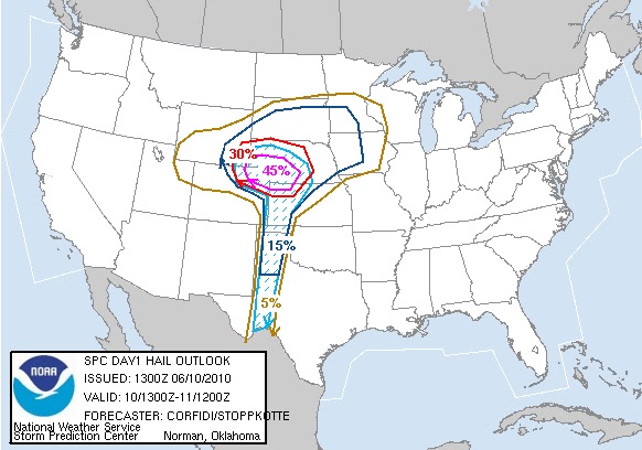
Start of Day 3 with a Moderate Risk Posted
What a nice surprise to wake up to this morning as SPC has upgraded the slight risk to a moderate risk. We're currently in almost perfect position this morning as the drive to the storms should be pretty quick. So right now I'm finally getting my oil changed and relaxing in gorgeous Fort Collins, Colorado.
Today the trough finally starts to make it's appearance as the upper and mid level winds have turned to the southwest while low level winds are from the southeast. So effective shear 40-50kts and moderate helicity values will promote rotating storms and the possibility of some tornadoes. The Cap that got us the last two days will still be an issue for the majority of the outlook area. However where we're targeting, the upslope of the mountains, a little cooler 700mb temperatures and some forcing from the approaching trough. Will likely help spark off the t'storms and once they do the environment will help maintain them.
Latest 12z RUC and 12z NAM place the surface low in different locations and will make a difference in where the t'storms form off the mountains. The 12z GFS is closers to the location of the NAM which is just to the east of Denver. Where the RUC places the low northwest of here in Fort Collins. Which would develop the t'storms off the Laramie range in southern Wyoming. So storms would likely move through Cheyenne and then drift east southeast into Nebraska and northeast Kansas by nightfall. I prefer and think the NAM has a better grasp on the trough coming in. So I think the storms will fire up from the southern Wyoming south to Denver by around 4pm Mountain time. Then will track east southeast and strengthening through the late afternoon into a couple nasty supercells. So right now my target location is Fort Morgan and adjust from there. I'm really loving that is only about a hours drive east from our current location in Fort Collins. =)
 I'll give you another update later this afternoon but for now look at the latest outlook from SPC.
 Got to love the Moderate Risk and the tornado threat being 10% in our location. However will have to watch out for the Large Hail as the probabilistic is up to 45%.

Wednesday, June 9, 2010
End of Day #2 and a little Grumpy! =)
Cap-2 Chasers-0
Well the lid on the atmosphere once again won as the cu towers just couldn't get going across the front range of the Rockies. So we're in for the night watching the Blackhawks game( Go Hawks!!) here in Fort Collins,Colorado. So nothing really to discuss and I'm to be honest a little aggravated. I thought one of the first days would produce at least an isolated strong storm. Hopefully the better looking days all week Friday and Saturday will still come true. Btw thanks for the all the clicks on the website and viewers of the dash cam!
See ya in the morning with a new forecast discussion and target area.


Night
Well the lid on the atmosphere once again won as the cu towers just couldn't get going across the front range of the Rockies. So we're in for the night watching the Blackhawks game( Go Hawks!!) here in Fort Collins,Colorado. So nothing really to discuss and I'm to be honest a little aggravated. I thought one of the first days would produce at least an isolated strong storm. Hopefully the better looking days all week Friday and Saturday will still come true. Btw thanks for the all the clicks on the website and viewers of the dash cam!
See ya in the morning with a new forecast discussion and target area.
Here is a sneak peak of tomorrow's and Friday's SPC outlooks


-Justin-
Day 2 Morning Briefing
Well greetings from lovely Dodge City, Kansas. Yesterday was pretty boring day as we left Oklahoma City roughly around 2pm. Headed west on I-40 then north to Buffalo, Oklahoma where we watched a couple elevated showers develop and quickly die out within an hours time. At that time I made the call that we just head north to Dodge City. Get some food, a hotel and a good nights sleep.
Which here I am in the Days Inn breakfast area looking over the latest observations and computer models. Today definitely looks like an up slope day off the Rockies as the there isn't much in the way of large scale forcing. The cap is fairly strong and will be an issue away from the mountains but expect to see at least a couple isolated storms from firing by mid to late afternoon.
Moisture will likely quickly increase under southeast winds as a lee side low develops around Colorado Springs area. Models this morning have increased the dew point levels just a tad here across eastern parts of Colorado. So I expected dews to run from near 60 near the Wyoming/Colorado border to maybe middle to upper 60s along western Kansas. This will likely help CAPE values climb into the 2,500 to 3,000 range and with 40-50kt effective shear. Supercells do look likely with large hail as they drift east/southeast. Tornado threat will be highest across southeast Wyoming and northeast Colorado as it looks now with fairly weak 850 winds but great turning from 0-3km.
So with that being said and me having a very sluggish morning I'm going to say goodbye for now.
Target Area: Sterling, Colorado expect storms to go severe after 4pm mountain time.
Tuesday, June 8, 2010
The Start of Chasecation 2010!
Greetings everyone and welcome to the fun adventures of Justin, Becky and BJ. Later this afternoon we'll leave Lawton, Oklahoma for 6 days on a road trip of fun and hopefully some crazy chasing. Right now I just got home from work and putting the final things in the car. BJ had a slight detour overnight and has placed him about 3 hours behind schedule. While Becky my niece is on a flight currently from Indy on her way to OKC. However we should all be together and hopefully leaving OKC by 2pm this afternoon.
Looking at the newest models coming in as I go through them quickly while typing this. The severe threat looks decent in our chaseable area, the tornado threat doesn't. Current target zone will likely be the nnorthern Texas Panhandle or northeast Oklahoma. Today I'm choosing to pick a target that is along the direction we need to go for the days to come. As tomorrow through Friday looks to be northeast Colorado into southwest Nebraska. So right now I'm hoping to be staying in Garden City, Kansas or Oakley, Kansas tonight. That way we can all sleep in and recharge our batteries for some nice chase days coming up. Even though the trend is to really weaken the upper level low as it become cut off. So the jet is weaker as well not helping us at all with the tornado threat. We will see as things can change at the synoptic level and very quickly during the afternoon at the mesoscale level.
Here is the latest SPC outlook for Today and the Tornado Probabilities


I'll try to keep you posted later but I'll be the driver today. So until we stop and not have any storms to chase. Just keep checking the live cam link above to see if we're streaming.
-Justin-
Saturday, June 5, 2010
Major Severe Weather Possible Later Today for Ohio Valley

Stay Tuned and keep abreast of the changing weather conditions in your area.
**Side Note- Latest models for next week's Chasecation are looking favorable for some nice active weather** =) -Justin-
Friday, June 4, 2010
I'm Back!! Computer is now back from the dead
A busy stretch for me as my website took the toll of it. As my computer crashed, was working doubles with severe weather and I just got back from vacation.
So I'm trying to get my recent chases together and write summaries for each of them. This year has been another slow one for down in the Texoma region. Late start and what is looking like a very fast end to the storm season. However when we did have severe weather the ingredients were ripe for some season action. It just happened to be just to the north and east of the viewing area. I would complain a little more but I have seen more this year then all together last year. I also have my vacation dedicated to chasing coming up next week with my niece Becky coming along again and my good friend BJ making it down from Indy. So hopefully we can get some great pictures and maybe bag a couple naders. As I could really go for a steak dinner. =)
So make sure you check back next week for Daily Chase Targets, Updates out in the field and of course Live Streaming Video. Starting Tuesday Afternoon June 8th and running through Sunday June 13th.
Justin
Subscribe to:
Posts (Atom)