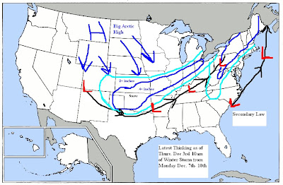
The model can't handle the Western trough. The new 114 off the 6z, though farther east and weaker than the Calorevada bomb it had, is still wrong. Instead, the UKMET and Euro are in much better shape, as they do not overdo the cold air feedback over the Rockies that deepens this too much. Instead, they send a piece of it out through the Plains Sunday and through the Northeast Monday, driving the arctic boundary back to Texas and pushing cold air east through the Ohio Valley and Northeast. The escape of the energy, plus the colder boundary conditions, force the wave to develop over Texas.
In addition, the weaker Western system is flatter until it bombs out near the East Coast. So, no low cutting to the Great Lakes, but instead a storm running east-northeast out of Texas to near Huntington, W.Va. with a swath of heavy snows from the Texas Panhandle through much of the Midwest, and then north of the Mason-Dixon Line to interior southern New England. This storm should turn to rain on the coast, but the GFS is missing the boat, in my opinion, on the energy that comes out in front (1) the cold air that comes behind that (2) and the track of the storm, farther south (3) before it bombs out. This will be a major winter event, with beat-the-numbers cold behind it south through Texas, and then to the East Coast. My take is that the negative AO and NAO are taking over, and it's time to start taking this into account when looking at the modeling......Especially the GFS with it's nortorious feedback problems during El Nino years and the Western Ridge and split flow.
Afternoon Update: 2pm
Here is my latest thinking of snowfall and storm track from next Monday-Thursday. As this storm will have very cold air spilling down the Plains behind it. More on this to come as the models continue to come around to what the pattern is setup for. True Arctic air is no match for the warm air to the south and the models continue to not see this. There will be a some precip and snowfall across the Central Plains and Ohio Valley Monday into Tuesday prior to the main storm system.
Latest 18z GFS is starting to come on board now but we'll really start to understand the storm when it gets within 90 hrs. Here is the map for Tuesday Eve at 7pm. Notice the Low pressure centered in Western Oklahoma about 100 miles further north then I'm expecting it. I also think the GFS is strengthening it too fast as it won't really start to deepen until it gets to Northern Texas then start moving northeast.


No comments:
Post a Comment