First lets talk about the tropics as hurricane Bill continues to be a powerful storm. Now a Cat 4 hurricane with 135mph sustained winds. WNW movement has continued by as you see below the models and the NHC continue to predict a northward turn. I'm still very worried for the Northeast coast Sunday and Monday. As any job to the west from the storm will put them in Hurricane force winds. That includes the city of Boston that is looking at a lot of rain from a frontal boundary. Then as Bill gets closer increasing winds and rain, how much that is still to be seen. Ana is no more and any life to her yesterday was sheared apart by the upper level low. Still lots of heat energy in the Gulf of Mexico with improving upper level conditions for now. However the upper levels become more southwest as the trough now across the Northern Plains swings to the south. Still watching closely but at this time it looks like I was wrong about redevelopment in the Gulf.

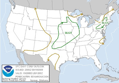
Now to a more current issue across the lower 48 states is severe weather. Currently one tornado watch posted but another one may be posted soon across parts of Oklahoma. Here is the latest SPC outlook for severe weather for this evening. Two main areas of concern are across Illinois with a broken line of severe t'storms. The second hot spot is from southwest Oklahoma north to southern parts of Kansas. This area will likely light up with severe t'storms some being super cells capable of producing large hail and a isolated tornado.
As you can see the Severe threat continues tomorrow into the Ohio Vallery and southern Mississippi Valley. Main threat will be more damaging winds and some hail then tornadoes.

Strong cold front and trough continues to surge its way south. As much cooler and drier weather takes over from the Plains east to the East Coast by early next week. So if you live especially along and east of the Mississippi river. Prepare yourself for some cool nights and mild to warm afternoons.


No comments:
Post a Comment