Sunday, November 23, 2008

Arctic Plunge on the way

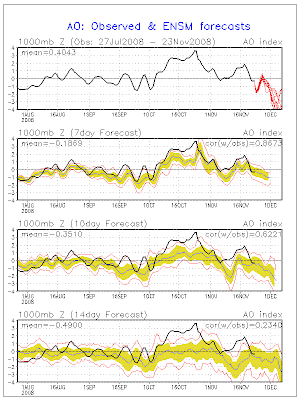
Ensembles and teleconnections continue to support a major cold outbreak as we head into December. As mentioned back in October and stated again last week. Is that I continue to predict a major cold wave in December. If you remember back in the Winter Forecast I mentioned the year 1989 as one of the years showing up on the anomalies. Well we might challenge some of those records from 89' especially across the areas east of the Mississippi River. Here is the latest Arctic Oscillation which is showing it tanking negative as we head towards mid-month. Also the latest GFS ensemble which show well below normal heights with the upper level winds coming straight south from the North Pole. Keep checking back as I'll be posting a more detailed forecast for the Thanksgiving holiday and Upcoming Cold weather.

Thursday, November 20, 2008

A chilly November will turn active

As advertised by my Winter Forecast things have turned out chilly for portions of the Central and Eastern United States. Currently Cold Air was racing south across the Plains and into the East as this will be the final shot of really cold air for the next couple weeks. Now that doesn't rule out some cold air but nothing that will drop highs some 15 to 25 degrees below normal. As a pattern change is occurring and will start to be felt as we head into Thanksgiving week. This will mean great news for the fire ravaged areas of Southern California. They will be likely seeing a wetter two week period starting next week and lasting into the beginning of December. The jet stream will likely take a split flow as the northern branch will shift a little further north from west to east. As the southern jet gets active from the four corners and across the Southern Plains. Here is how below normal we have been over the past week across the US.
This pattern change has been supported for over a week now on the European and GFS ensembles but not until the last couple of runs on the actual GFS model as the European model has been handling this pattern the best. Now this will likely be a battle of the jets as the cold air will be making another charge indicted by the latest Arctic Oscillation(AO) as it goes Negative so do the temperatures across Canada and the US by the 10th of December.
Again just like I mentioned on my Winter Forecast the Climate Prediction continues to hold on to its warm bias of the winter season. As they're predicting a warmer than average month for the central Plains and no below normal temperatures across the US. As I believe the above normal will be more towards the Four Corners area with Below normal across the Northern Plains and alot of areas east of the Mississippi River. As I mentioned above, the cold air will be arriving in a big way by around the 10th of December. Here is the Climate Prediction Center December Outlook. Which is obvisously not seeing what I'm seeing.

Here is what I see happening in a general description over the next two weeks. This weekend a storms develops over the Ohio Valley and into the Interior Northeast with a mix of rain and snow. This will bring a cold shot of air but further north and east as the last two so no real cold gets pushed west of the Mississippi River. Then as energy dumps into the West and the northern Jet lifts north and becomes more zonal. This will allow the Southern Jet to lift north and phase with the energy diving off the West Coast. Then by Thanksgiving or the weekend following a piece of energy out of the Polar Jet with crash into the Northwest and either pick the energy up or phase with the energy hanging back into the Southwest and Southern Plains. This will then create a rain and snow storm that will either head up towards the Lakes or head east then reform across the Mid Atlantic and head northeast. As Arctic air gets drawn in behind it into Canada but I think this storm just sets the stage for the full blast of Cold air coming in about a week behind this storm around the 10th of December. This will likely place high temperatures 15 to 20 degrees below normal with widespread snow cover starting to show up from back to back storm systems. Here is last years and then the current Snow Cover Map as of the US.

So enjoy the moderating trend over the next 7 to 10 days across the Central and Eastern United States. As the rains finally develop across the south the cold air builds north. Then will finally meet to become a very fun, cold and snowy Holiday time period. Its beginning to look like a White Christmas as we'll be talking about the possibilities of that here in the coming weeks. Thanks again for checking out my website and encourage you pass this site along to others and help me grow. Justin
Wednesday, November 12, 2008

11-10-08 Severe weather recap

November 11th, 2008 Severe weather recap

Total Miles- 151 miles
Total Storms- 1
Tornadoes-0
Hail- couple pea size hail stones
Wall cloud- One very ragged one that was quickly demolished by outflow
Damage- None
Max Wind Gust-36 mph inflow and 41 outflow recorded by Interceptor
Very interesting chase as things during the morning seemed to only get better to end up as a bust. The majority of Texoma had a slight risk with a greater risk of severe weather to the southeast of the area. By 11am the warm front continued to very slowly work it way north as a 700mb dryslot was quickly racing northeast across the area as skies become partly sunny. Then by 1pm a couple isolated showers started to develop just south of the warm front and in front of the dryline was slowly pressing east. Here is the radar view and SPC outlook as we headed towards the cell from the station at 1pm. A tornado Watch was also issued for our southern counties marked in a red box on the radar below.

As we headed towards this cell to our southwest the weather conditions changed greatly as we went from cloudy with temps. in the upper 50s to temps to near 70 degrees. Once we arrived and got into position to watch the storm just east of Devol on highway 70. The storm started to intensify within ten minutes as a severe t'storm warning was issued at 1:39pm. We're at the location of the white circle just northeast of the storm. Nickel to Quarter Size hail was reported to our due west around 1:50pm.

At 2:15pm I did a call-in on air as we were on the air doing severe weather coverage. However at this time the storm had crossed the warm front and become outflow dominant. Then we decided to head south towards Wichita Falls and caught this last attempt to organize.
We then headed south on highway 281 south of Wichita Falls into Archer County. Where we parked and looked to the west at the dryline about 50miles to the west. Hoping with all the sunshine, temperatures in the lower 70s and dewpoints in the lower 60s. That more severe thunderstorms would fire up and take advantage of the decent helicity values. Well the cap was to strong and the forecasted shortwave was slower in coming out and was less negatively tilted as advertised. So we headed back to the station at end the chase by around 5pm.

Monday, November 10, 2008

Another Severe Weather Outbreak probably bigger

Wow, looking at some of the model data and surface analysis paints an very unstable atmosphere later this afternoon. Currently the SPC has a slight risk from parts of Oklahoma south into Texas. After looking at things this morning I wouldn't be surprised if they upgrade portions of the slight risk into a moderate risk. As very strong upper level winds will overlay the turning of the winds near the surface to promote the development of supercells by mid afternoon. The likely moderate risk area will be from Abilene to just south of Dallas to along I-35 west to near Junction, Texas. This area will have the greatest threat of tornadoes including some strong tornadoes by late afternoon. For the Texoma area we're watching how far north the warm front moves and how much sunlight/heating we can get by mid afternoon. Currently there is quite a bit of clearing off to the south and west. As storms have already pulled north of the viewing area for the most part. This could be another chase day for me across North Texas as I'll probably head out by 2pm. Latest Outlook posted at 7am Central time.

Sunday, November 9, 2008

Another day of Severe weather in November

Greetings from Texoma on this crisp chilly morning in early November. Which from the feel of the air this morning, its hard to imagine I'm posting about severe weather. However a small vigorous shortwave is charging its way south and east across California currently. Modified tropical air is now starting to make its surge north across northern Mexico and far southern Texas. As upper level divergence and lift starts to move over the moist air showers and t'storms will form very late overnight into Monday morning across Northern Texas and parts of Oklahoma. Some of these storms will be capable of producing hail up to quarters. Then if the clouds and rain of the warm front can pull north and east of Texoma. The dryline moving across the area during the afternoon and evening could produce more severe weather. The models have continued to decrease the speed of the system and the veering of the winds. So severe weather is looking more and more possible for portions of the area. I'll have another update later on this evening as some of the short models will start coming in. Stay Tuned! Here is the latest severe weather outlook from SPC..... Monday OUTLOOK

Thursday, November 6, 2008

Severe Weather Recap for 11-5-08

November 5th, 2008 Storm chase Recap

Total Miles- 154 miles
Total Storms- 3
Tornadoes-0
Hail- Fallen dime to nickel size (covering the ground)
Wall cloud- 3 with one with slow broad rotation
Damage- wind damage 60-70mph (micro burst)
Recorded wind gust of 47mph on Interceptor

Started the day with a nice slight risk area for our eastern counties of the viewing area in southwest Oklahoma. As storms were forecasted to start firing along a dryline by 3pm right around Lawton and points east. By 1:30pm a small shower started to develop just north of Lawton in Caddo county. This however was having a hard time getting going so around 2pm Ollie(station photographer) and I took off north on I-44 heading northeast to Chickasha as a Tornado Watch was posted for the area. As we were heading northeast we noticed several towers going up to our southwest which was good news because the storms raced northeast at around 45mph. So it was pretty much get ahead of them and watch them go by and try to keep up with them for a little while.
So as we reached Chickasha we noticed that the storms to our north we racing out of the area so we got into position to intersect the storms north developing over Lawton. So we head down highway 81 towards Rush Springs were we watched Storm#1, Storm #2 and Storm #3 from. Storm #1 wasn't warned by was very photogenic with a nice rainshaft and great updraft tower. Storm #2 as it passed to our northwest gained strength quickly and was warned from our area north for large hail up to quarters. Storm #3 from this location developed very quickly and dumped very heavy rain right overhead then produced a beautiful rainbow and rainshaft in the sun(see pictures).
Then thing calmed down a little as we didn't see any real towers going up to the west. So we decided to head a little south towards Duncan as a small shower was developing on Cotton county to the southwest. This would be our last storm as sunset is at 5:30pm now. So we headed on the westside of Duncan and found a great viewing spot. We then watched this storm develop from a thundercloud with very little falling precip to a very strong storm as it passed overhead. This storm became better organized as it raced northeast towards us. As the meso passed right over us a severe t'storm warning was issued for the storm. As radar and also by sight was showing this storm really starting to wrap us a little. Shortly before passing overhead a small RFD notch started to cut into the updraft as rising scud quickly formed a wall cloud. As it passed overhead it displayed lots of movement and a very broad but distinct circulation as we got hit with a wind gust of 47mph from the RFD. This eventually developed a decent wall cloud for about 10 mins as it raced northeast. We packed up and followed it as it tried to lower several times. As we headed behind it we went through the city of Marlow which had been turned into a winter wonderland with dime to penny size hail covering the grass like a light dusting of snow. As night fell the storm weakened but was still producing inch size hail as I did a phoner for the top of the 6 o'clock news. I was then told after doing my report from the field that wind damage had been reported in Duncan about 3 miles northwest of the location where we were watching the storm from. So we found the gentleman's house and took some footage of his downed tree, blown over fence and shed that had been pushed off this foundation. It looked like a microburst of around 60-70mph as it was a very small area of damage.

According to the SPC there were 137 reports of severe weather with 4 tornadoes reported in far southwest Missouri overnight.

Here is a link of the entire photo gallery from this chase.... Enjoy the Pictures