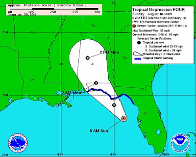
Just as mentioned yesterday a tropical depression has formed in the northeast Gulf of Mexico. This depression will likely be named Claudette and become a tropical storm in the next NHC update. For the latest information from the National Hurricane Center click here.
This storm will likely make landfall at a moderate tropical storm with sustained winds around 55mph. As the Gulf Coast is a little lucky the forward momentum is still pretty quick at around 16 mph. Landfall will likely be later this evening with some gusty winds but the main threat will be torrential rains. Apalachicola,Florida looks to be pretty close to where Claudette will make landfall. Main threats will be some gusty winds just east of the center. However winds will be in a very small area and for the most part not damaging. Tornado threat will increase across Florida and eventually across Alabama and Georgia. Torrential rains causing some flooding is likely as up to 8 to 10 inches of rain will be possible.


No comments:
Post a Comment