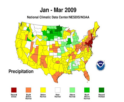
Alright now to what has seemed the never ending end to winter. Which if you remember I mentioned that it we would have a late spring, especially in the east. ( patting myself on the back..haha). Here is the Temperature and Precipitation means from Average for the Month Jan-Mar.)
So you say what is next on the ole weather agenda? Well the split flow we're in with the main jet stream split across the U.S. is about to end. The map below is the 500mb height mean anomaly which shows if the temperatures at the 500mb heights are cooler or warmer than average. The split flow with bowling ball storms and shortwaves are pretty common in late spring of La Nina years. Last year this also occurred but was a little later in the spring in May. Which caused lots of tornadoes in the central plains and into the Mississippi Valley. This year since its April and the southern jetstream has kept the really moist tropical air south of the Storm track. So the tornado number is about on average, based on the storminess across the country you would think it would be a lot higher.
Alright back to the 500mb map, if you look into central and eastern Canada there is a lot of warmer heights which is acting like a block. So any cold air that builds across Western Canada comes straight southeast into the Eastern United States. So although its cold over this weekend and early next week. The winter pattern is saying goodbye as a major warm up takes over for the entire U.S.. This will send temperatures into the 70s and 80s into the Great Lakes, Ohio Valley and entire east coast by next weekend. If you look at the 500mb maps below you can see by the end of the month the blocking disappears. We get into a more west to east flow with warmer heights below and cooler ones up north. This will also turn off the rainy and stormy pattern over the East.


So say hello to Summer finally over the East as the nasty late winter pattern is finally saying goodbye. This is however with one last gasp of bitterly cold rain and some snow over the Great Lakes, Ohio Valley and Northeast. Here is a look at the Climate Prediction Center to the next 6-10 days... Can you say hello Summer!


No comments:
Post a Comment