

Brutal cold air is aimed for much of the lower 48 states over the next two weeks. As a large ridge builds across the Pacific and west coast of the US and Canada. Will dislodge temperatures right now across Alaska and the Yukon territory of Canada in the range of -40 to -60 degrees below zero.
As the weak La Nina mentioned in the Winter Outlook has been confirmed by the Climate Prediction Center. Here is the general storm track and weather for a La Nina. Can you see the similarities to our weather pattern for the past 60 days? 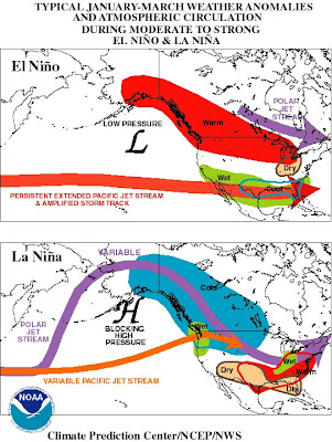
During the next two weeks a ridge will build in the West and a big trough will dive into the East. Causing plenty of cold air to overwhelm the Plains east to the East coast. As the Polar vortex will head south and will likely be in the Great Lakes by next weekend. This will cause days across the Northern Plains to never reach above the teens below zero. Chicago and portions of the Ohio Valley to have high temperatures near zero degrees. Even down into Texas and the Gulf Coast high temperatures could be in the teens and twenties. This cold outbreak could be the coldest since the extreme outbreak in January of 1994. 
Now before the Siberian Express shows up we have to deal with an Alberta Clipper with some Arctic air behind it for the weekend. As the low pressure will race southeast to around St Louis by midnight tonight and then east towards the Mid Atlantic states by tomorrow afternoon. Here is snowfall map that shows the general thinking of snowfall over the next 48 hours. 
Here is one of the computer models predicted high temperatures for next Thursday 15th...Brrr!

No comments:
Post a Comment