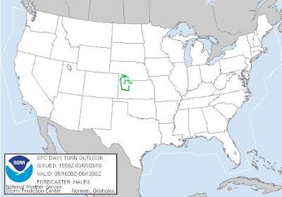
Warmer temperatures and a different weather pattern is starting to show early Spring conditions across the Central Plains today. A small but potent storm system comes out of the Rockies into Nebraska and Kansas during peak heating. A more potent storm system moves into the Southern Plains Sunday and into Monday. This will have more moisture and better dynamics to deal with. Heavy rains look likely from N.Texas north to Southern Kansas during Sunday. However a cold core setup with a dryline looks possible on Monday. Many questions still out there with the quality of moisture, lapse rates, morning convection and cloud cover. However the first chase of the year for me could be days away but right now its only a slight chance. =)
Here below is the tornado threat and write up from SPC.
A 40-45KT LLJ HAS DEVELOPED ACROSS CENTRAL HIGH PLAINS IN RESPONSE
TO THE LEE TROUGHING ERN CO AHEAD OF THE S/WV TROUGH. ALTHOUGH LOW
LEVEL MOISTURE IS MARGINAL MOVING NWD THRU THE HIGH PLAINS...THE
COMBINATION OF VERY STEEP MID LEVEL LAPSE RATES...8C/KM OR
GREATER...AND COLD AIR ALOFT WILL BE MORE THAN SUFFICIENT TO SUPPORT
THUNDERSTORM DEVELOPMENT BY OR SHORTLY AFTER PEAK HEATING.
WITH SURFACE TEMPERATURES CLIMBING THRU THE 60S IN WRN KS AND
DEWPOINTS RISING INTO THE MID 40S...MUCAPES WILL STILL ONLY BE ABLE
TO REACH TO AROUND 500 J/KG BY 21Z AHEAD OF THE DEVELOPING N/S DRY
LINE FAR WRN KS.
SURFACE BOUNDARY FORECASTED TO MOVE EWD AHEAD OF UPPER SYSTEM ERN CO
DURING THE AFTERNOON WILL LIKELY BE THE PRIMARY FOCUS FOR CONVECTIVE
INITIATION AS IT OVERTAKES THE DRY LINE IN WRN KS INTO SWRN NEB.
GIVEN THE COLD AIR ALOFT AND STEEP LAPSE RATES...HAIL WILL BE LIKELY
ASSOCIATED WITH ANY STRONG UPDRAFT. THERE IS THE POSSIBILITY GIVEN
THE LARGE SCALE UPPER SUPPORT AND VEERING SHEAR PROFILES...THAT
STRONGER STORMS WILL BE ABLE TO BRIEFLY ROTATE INCREASING THE THREAT
OF LARGER HAIL AND EVEN A BRIEF FUNNEL AND/OR TORNADO.
CONCERN FOR ANY MARGINALLY SEVERE STORMS SHOULD END BY EVENING AS
LOW LEVEL LAPSE RATES WEAKEN WITH ACTIVITY MOVING EWD TOWARD
SCENTRAL NEB/NCENTRAL KS.
..HALES/ROGERS.. 03/05/2010
Friday, March 5, 2010
Wednesday, March 3, 2010
Monday, March 1, 2010
The Unofficial Start of Storm Season and Meteorological Spring
Welcome to the unofficial start of storm season for the lower 48 states. Oh ya by the way it’s the start of meteorological spring as well. Typically by the start of March we start to see the storm track a little further north and storm become a little stronger. As the battle of air masses starts to heat up as daylight hours really start to lengthen.
Right now the United States has seen a fairly chilly winter and looks to remain that way generally for the next 2 to 3 weeks. So expect some warmer temperatures as average highs are starting to move up the thermometer but I wouldn't expect any record highs in the near future. As you can see high temperatures continue to be fairly chilly across the US.
Now that we're into March we'll have to closely watch each storm closer for the chances of severe weather. Right now all is quiet for the next 4 to 5 days but by early next week severe weather could develop with a strong low pressure in the Central Plains.
Stay Tuned!
Justin
Monday, February 22, 2010
Snow and More Snow for the South
*Map is of the total snowfall until Wednesday morning**
The winter of 2010 continues to chug along as another very active period continues to set up from now until mid March. Then maybe just maybe the cold and snowy weather starts to retreat a little further now. Until then the coldest temperatures relative to average and heaviest precipitation will be from the California to Texas to the Carolinas. Texas and Louisiana will continue to be one of the wettest locations and possibly one of the snowiest over the next 10 days. Storm #1 currently moving across the Southwest will moves across the Southern plains tonight and through the day tomorrow. Producing accumulating snows across I-20 in Texas and as far south as Austin and Houston. Then weakening but still producing some snow across Louisiana and Mississippi. So one of the snowiest winters on record for many parts of North Texas continues to be added onto with another 1-4 inches possible by tomorrow afternoon.
Storm #2 moves in a little further north on Thursday across parts of Kansas and Oklahoma. Some warmer air will be able to build ahead of the low pressure system. So rain will be a bigger part of this storm at first until you get into Northern Oklahoma and Kansas Thursday afternoon. However as the low slowly strengthens and drifts southeast some colder weather will likely change the rain further south to snow. So accumulating will fall from Thursday night and through Friday from parts of Kansas and Oklahoma. Parts of Texas will likely see just mainly light rains. Then on Friday the accumulating snow move from Northeast Oklahoma to parts of Arkansas and again across northern Louisiana.
Storm #3 is possibly papa bear and could be a major late winter snow storm from coast to coast. That could create heavy rains, severe weather, ice and heavy snows. So stay tuned as March could come in like a lion across a good portion of the United States.
Thursday, February 18, 2010
What does the next 30 and 90 days have in store for us?

These graphics are from the Climate Prediction Center which came out today. Definitely agree on the cooler than average temperatures east of the Rockies the next 30 days. The southern jet stream will be very active through early spring. So you can expect wet weather from California to Carolina and an active pattern. I also believe that parts of the I-20 corridor from Texas to Georgia could not be done with the ice and snow. We'll see but here are a couple things to chew on until I get back in town next week.
Have a great weekend!
Justin
Tuesday, February 16, 2010
Welcome to the website Chasing The Meso (Under the influence of Mother Nature)
Hello and welcome to my website if you're here for the first time. This website is designed to provide medium and long range forecasts during active weather across the Central and Eastern US. Plus during spring and summer seasons I’ll post severe weather forecasts and blog my chasing adventures. So feel free to look around and check out my prior chases over the last couple of years.
Currently I'm in the process of reorganizing and better preparing for this upcoming storm season. So expect some changes coming in the next month and better chase summaries.
Thanks again for taking a look at my website and have a great day!
Justin Rudicel
Currently I'm in the process of reorganizing and better preparing for this upcoming storm season. So expect some changes coming in the next month and better chase summaries.
Thanks again for taking a look at my website and have a great day!
Justin Rudicel
Subscribe to:
Posts (Atom)


