Monday, April 18, 2011

Wet & active pattern starts to shift west

While the Southern Plains continues to bake & burn in the midst of a severe drought. Relief could be on the way here in the next 5 to 10 days. Which is much needed looking at the latest drought index.

Parts of Oklahoma and Texas have had less than one inch of rain since the middle October. This is the driest it's been for the months of December-March since 1921. While parts of the Ohio, Tennessee and Mississippi Valleys have been very wet & active. Signs of this pattern shifting a little west have popped up on the models for the past two weeks but have yet to materialize. This is now changing and in motion with rain looking more likely and possibly widespread by late week. Here is the latest 5 day QPF outlook from HPC.
Now another aspect of this pattern change and more active weather here in the Southern Plains is the chance of severe weather. Right now many possibilities exist in the models as to where the fronts, troughs & low pressure end up. So I'm going to wait for another post to get into details on that aspect. Currently it looks like Thursday and Sunday could be very active days with regards to severe weather. So finally we might see rain and chasers here in the Southern Plains will get to play a little. 

Friday, April 8, 2011

First Chase of the Year only hours away

Slight chance of an isolated severe t'storm still exist close to home this afternoon. So with plenty of instability, weak CAP and dryline for a trigger. I plan on being out by 4pm central time chasing what I hope is a nice big supercell.  Don't forget you can watch my streaming video here on this website just click on Live Cams on the top.

Currently SPC doesn't have any area near SW Oklahoma under a risk of severe weather. As they focusing on the warm front extending from far northern Oklahoma to Kentucky. They have noted there could be a storm down the dryline but didn't mention in slight risk because of the small chance of initiation.

Don't forget to add me on Twitter for Chase updates- Twitter-Chasingthemeso

Should be leaving the station around 3pm so the chase cam will be up shortly after that.

Sunday, April 3, 2011

Severe Weather & Extreme Heat

Spring has been fairly slow in regards to severe weather but that could be changing over the next week or two. As the pesky cold air and trough in the east is showing signs of breaking down with the mean trough developing into the west. This is supported by the NAO going positive and the PNA going negative forecasted by the models. So tonight's into Monday severe weather event could be the start of more frequent bouts of severe weather from the Plains into the east.


Today looks to be a very warm to hot day across the Plains as south winds continue to surge moisture north. This will interact with a sharp cold front that will quickly dive east/southeast tonight into tomorrow. The limiting factor of today's severe weather will be a warm layer of air aloft above the surface called a CAP. Looking at the soundings this morning, it is very likely there will be very little convection prior 0z (7pm) from Kansas south to Texas along the dryline. Storms will likely start to form from Iowa to Kansas after 7pm as the cold front catches up to the dryline as the linear forcing can lift the air over the cap.

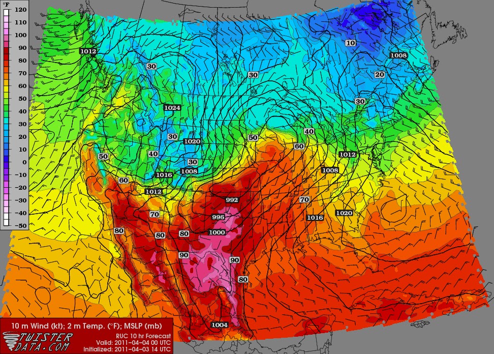
   Hot Temperatures!! Areas in pink are over 90 degrees on April 3rd!

Now even the cap will most likely inhibit storm develop during the day. The situation is definitely not something to ignore due to the explosive environment from Iowa to Oklahoma. Here below is a sounding at Topeka, Kansas the shows a shotgun sounding. Meaning that if the parcel can break the CAP the air will explode upwards allowing for explosive development of t'storms.


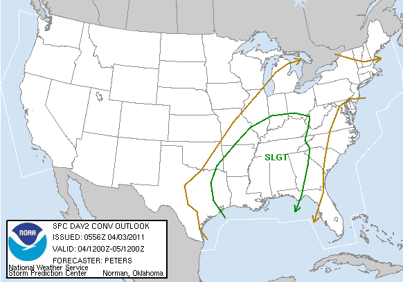
Eventually the cold front takes over and storms will explode up from Illinois south to Texas in more of a linear fashion. This broken line of storms will have the risk of very large hail and damaging winds as it heads southeast towards the Mississippi Valley by Monday afternoon.  Here is the SPC outlooks for Today and Tomorrow.


Wednesday, March 30, 2011

No Chasing in March But Could April Start with One?

Models continue to be iffy with the timing of the upper level energy, deepth of moisture and a pretty stout cap. However with the amount CAPE, Upper level winds and a Dryline nearby. I'm watching closely Sunday afternoon for a possible isolated Supercell from southwest Ok into N. Texas. Here are some maps from the latest 18z GFS that shows a very powerful atmosphere with a nice lid but not unbreakable lid on it. Many things will change as we head into the weekend but wanted to give a heads up on what i'm watching. Could the first chase of 2011 actually happen or will I have to wait another week? We will see.....
                                                                  CAPE 0z Sunday Evening
                                                                CIN 0z Sunday Evening
                                                            Dewpoint 0z Sunday Evening
                                              Sounding 0z Sunday Evening S. of Lawton


Thursday, March 17, 2011

When will or will the storm season arrive here in the Southern Plains!?

Looking at the latest 8-14 analogs and GFS ensembles the dry conditions across the south look to continue. As the NAO continues to disrupt the overall moisture feed from the Gulf with a high pressure over it.


From the March 2011 Enso Update
"The moderate to strong La Niña conditions that were observed betweeen mid-August 2010 and early February 2011 have weakened to weak to moderate strength as of mid-March 2011. For the March-May season currently in progress, there is an approximately 75% probability for continuing La Niña conditions, and a 24% probability for returning to neutral ENSO conditions. Probabilities for La Niña conditions drop to just below 50% for the April-June season."

So where were the tornadoes in the Springs of 71', 74 & 99'?

I'll try to get the maps together here in the next day or two. Hopefully that'll give me some hope but here in the Southern Plains. We could be looking a pretty bad drought this summer with limited storms to chase this spring.

Friday, March 11, 2011

A Very Active Last 10 days of March?

Over the last couple of days the 8-14 day analog have been increasingly pointing to an active period across the Plains and into the Midwest.
So I took the top four years on the list and looked up the storm reports centered on that date. As you can see by the examples below a stormier period could be on the way.  


 Storm reports and the overall weather pattern looks to be changing to a more trough, ridge, trough. However by looking at the NAO and PNA charts below. There could be an unfavorable trough off the east coast disrupting the streamline flow from the Gulf. This is due to the NAO going negative and supporting a trough and low pressure development off the east coast. So this could actually keep the southern Plains capped with warm temperatures.
Time will tell but we're definitely in need of the rain down here in the Southern Plains. We currently have over a dozen wildfires just in the state of Oklahoma this afternoon.