Thursday, December 9, 2010

Model Mayhem Continues!


Typically by 3 days out the model would have differences but no more than 50-75 miles. Currently some of the models have over 300 miles differences in them. So right now I'm really reluctant to post any snowfall forecast based on huge differences there could be. What I will post on here is what I know, what I think and some kind of broad forecast for all that is interested.

First lets start with what we know-
Intense Arctic air is building to the north and is ready to be pulled down into the lower 48 states. Snow cover across Canada and the northern United States continues to be at or slightly above normal. So no matter where this area of low pressure forms across the Great Lakes and Ohio Valley. It will have plenty of cold air to pull into it creating dangerous wind chills and the possibility of flash freezing as the temperatures plummet.


Forecast
Right now I continue to believe that the 996 to 998mb (moderate strength) low pressure will still track from Kansas through southern Illinois, central Indiana, central Ohio then turning northeast into southern Canada. While another low pressure deepens across the East coast east of Virginia. Currently the models have the low pressure further north from Nebraska to around Chicago to northern lower Michigan. While a few others keep a very weak low drifting east/southeast across Missouri, Tennessee and eventually off the North Carolina coast.  

Precipitation amounts are even more all over the place with the models. However just by looking at the setup from the upper levels to the lower levels. I can't see this not having at least a swath of snow on the northern side of the low track with at least 4-7 inches. Most areas around that swath will likely see far less but right now too many questions to really talk amounts. The biggest danger from this storm will not be its huge snow totals but with its high winds and brutally cold temperatures. Winds will likely increase from 20-30 mph with higher gust around backside of the low. This is happening while temperature plummet into the teens and even single digits during the night. Producing near zero wind chills and lots of blowing and drifting snow. So don't under estimate what a few inches of snow blown around can do to the streets and visibilities while driving.

Still have a full 24 to 36 hours before the system starts coming together. So once the energy comes on shore late tonight across the West coast. The models will have a full picture of the entire atmosphere and should really start coming together. Unfortunately this won't likely occur to the morning runs of tomorrow.

Justin
Wednesday, December 8, 2010

No Change in Forecast as Models Continue to Waffle

I will not change my initial forecast from Monday with the first low pressure riding from the Plains through the Ohio Valley and turning northeast. As the energy transfers to another area of low pressure deepens off the East coast to the north. Some models have continued to slow down the strengthening of the first low pressure. Thus the track will be more west to east from northern Oklahoma to central Kentucky. Models usually have some waffling around the day 4 and 5 time frame but usually hone in by day 3. So that's why I'm waiting to put a true snowfall forecast until tomorrow afternoon.

Still looks like heavy snow, high winds and very low windchill values are in store for most location east of the Mississippi valley. Time frame of this winter event will start on Saturday and start winding down on Monday across the Northeast.

Justin

22nd Most Popular Streamer on SevereStudios!

I receieved an email from Severe Studios(The website I use to stream my dash cam while chasing) stating I was the 22nd most popular streamer (based on number of unique viewers) out of over 400 on SevereStudios.com during the 2010 storm season.
SevereStudios

This year has also been a good one for the website as well with over 4,000 viewers since Jan. 1st!

Thanks to everyone that continues to check out the website and watching the live feed.

Justin

Tuesday, December 7, 2010

Quick Update On The Pending Winter Storm for Ohio Valley and Northeast

Models continue to converge on a major winter storm from the Ohio Valley and into the Interior Northeast over the weekend. I continue to like my original snowfall forecast from yesterday with the areas along and north of I-70 across Illinois, Indiana, Ohio getting the heaviest snowfall and expanded into the interior Northeast. Snowfall behind the low pressure will likely fall into Tennessee and into mountains of the Carolina's by Sunday night. Along with the snow comes plenty of wind that will increase behind the storm system as it heads into the Northeast. This cold wind will press a very cold airmass into the Southeast and even into southern Florida by Sunday night. Where numerous record lows will likely be broken from the Ohio Valley to Florida. As I'm getting very concerned about the crops across central Florida on Monday morning and again on Tuesday Morning. Where they cold seeing temperatures as low as the middle to upper 20s.

Stay Tuned! Another update tomorrow and on Thursday I'll have my snowfall forecast.....Little teaser... Some folks are going to be receiving over a foot of snow. Break out those shovels!

Monday, December 6, 2010

Significant Snow Storm for the East Later This Week?


During the previous week, several analogs and even the Hydrometeorological Prediction Center have mentioned the upcoming pattern very similar to a major winter storm late in the Fall of 1950. This crippling storm knocked out power to more than 1,000,000 customers during this event. In all, the storm impacted 22 states, killing 353, and creating US$66.7 million in damage (1950 dollars).
http://en.wikipedia.org/wiki/Great_Appalachian_Storm_of_November_1950

By no means does this future system look to be as powerful as the 1950 storm but it does have several similarities in the overall pattern. So this would mean a significant snow and wind for portions of the Ohio valley into the Northeast. Models continue produce a major storm system for the upcoming weekend. However the storm track, strength and speed of the system continues to change. Here are the four long range models for 120 hours and 144 hours. Notice the differences but also the similarities of producing a major storm system across the eastern third of the nation.


 Right now I like the look of the GFS and Japanese model based on the track and blocking across Greenland. The North Atlantic Oscillation (NAO) continues to be negative indicative of a continued trough across the East coast. So the low pressure should continue to track east instead of really turning north as it strengthens. Looking back at previous storm tracks in this pattern from the Pacific Northwest into the Nebraska area. The mean track is generally from Nebraska to Indiana into New Jersey. Most are generally fairly weak low pressure however the strongest storms have been in La Nina winters and with strong blocking across Greenland. So that is why i'm agreeing with the models that have been indicating a sub 990 low.

Right now I believe the heaviest snow greater than 6 inches with a greater than a foot and a half within this swath.Will run from the I-80 corridor from central Iowa east to northern Illinois including Chicago. Then from Illinois into Ohio the heaviest snow will likely expand south to the I-70 corridor. This will include Champaign to Indianapolis to Columbus and points to the north into Michigan. The winds will continue to increase as this storm deepens as it drifts southeast into Ohio. Causing lots of drifting snow, blinding visibilities and plummeting temperatures. Many changes to come over the next several days with storm track and strength.....The snow/rain line will continue to change north/south/east/west but this gives an idea of whats COULD come into your area by this weekend.

Let the fun begin! I'll keep you posted on the latest and will put an actual snowfall prediction out on Thursday.


Justin 

Wednesday, November 17, 2010

Better Get Those Xmas Lights Up Now...

Here comes the Arctic Chill as forecasted earlier this month on here...See Forecast Post

Per NAO and AO as you can see below which would indicate arctic intrusion and trough in the east.


And it looks like this will continue into the start of December as higher pressures in Alaska continues the arctic slide south with the NAO staying negative.

Looking towards Thanksgiving week, an arctic wave drifting south will meet up with an Pacific system. This will likely pull the bitterly cold air sitting to the north southward. As a wave of low pressure or a couple waves slides along the front while the cold air drifts south and east. Models continue to disagree on the evolution of cold air and storm system. However it looks like you definitely need to get those Christmas lights up if you live in the east. The cold is coming and looks to be sticking around for a while as the month of December looks pretty cold from the Mississippi river east.

Here are examples of the two main long range models the GFS(US Model) and the EURO( European). Right now I believe the 500mb pattern looks better on the Euro than the GFS. The GFS is sending too much energy ahead of the main trough (feedback). This will in turn help pump the ridge across the southeast and help phase the jet streams to dig in the trough as it slides east.


Trust me I'm tracking this closely because Laura and I will be flying on Thanksgiving day back to Indy. 

Monday, November 8, 2010

The Cold Builds to the North as Active Jet Stream Moves In

As mentioned last week, an active pattern is setting up across the central portion of the US. Current temperatures during the warmest part of the day are quite cold across Canada as you can see below.

This build up of cold air is just asking to be sent south and some will over the next couple of weeks. The kicker will be an active jet stream and low pressure across the interior west of the United States. The cold air looks to come down in waves so will likely modify some as it heads south. So portions of the central Plains could see snow falling by this upcoming weekend (north of I-70).

As several areas of low pressure come out of the west and head east/northeast towards the Great Lakes. Producing rain and some storms from the Southern Plains northeast into the Great Lakes region. Now this will just be the first of likely 3 or 4 storms over the next two weeks. Each one producing heavy rains but each one will likely press the snow line to the south. Right now the ensembles and long range models continue to point to a very cold(relative to average) mid month and Thanksgiving week across most of the US.

So anyone from the Texas Panhandle to Louisville to New York City and points to the north better be on guard for shoveling snow by Thanksgiving week. Places east of the Mississippi will likely see the real cold air not arrive till Thanksgiving week. So here comes the cold air as it will likely feel like late December in the third week of November. So I warned you and you better get those thermal long johns ready.

Here is the latest 8-14 day analomy and the latest 8-14 day outlook from CPC

Wednesday, November 3, 2010

Here Comes Winter....With A Sneak Peak This Weekend

The first nor'easter of the year is about to develop across the East as cold modified air rushes in from Canada. This will likely produce the first snow flurries all across the Ohio Valley and eventually as far south as the Appalachians and into the interior Northeast.


What I have my eyes on is a developing cold air mass in NW Canada and Pacific Jet stream that will likely buckle by mid month. As we could see our first major snowstorm of the year from the Central Plains and East into the Mid-Atlantic. Followed by freezing temperatures into the south from Texas to Georgia as temperatures could be in the single digits to teens across the north. Right now the time of arrival for this first major bout of winter looks to arrive between the 13th-16th of the month. Below is first the latest ensemble run of the 500mb anomaly and the latest 8-14 anomaly composite.

Tuesday, October 26, 2010

Historic Storm Continues to Deepen!

This is a storm now stronger than the infamous "Edmund Fitzgerald" storm in Nov. 1975 and an even stronger version almost exactly 23 years after that in Nov. 1998. Its central pressure is also on par with the infamous Superstorm of 1993, and is lower than the last 4 hurricanes of the 2010 Atlantic hurricane season. Currently the pressure is down to 957mb which puts it second on the list of lowest pressure ever in this part of the region. To reach number one it will have to fall another 7 millibars to beat the Great Ohio Blizzard of 1978. Forecast show it reaching 955mb before starting to fill back in.
Here is a map of all the currents wa

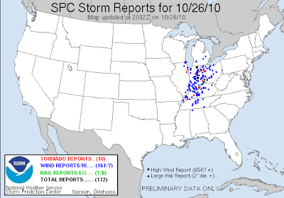
It continues to spawn numerous severe t'storms with damaging winds and tornadoes from Ohio and Pennsylvania south to Mississippi,Alabama and Georgia. Here is the latest map of all the storm reports so far.  
This threat will continue well into the evening as the low pressure finally starts to weaken and move into southern Canada.

Life Threatening Event Unfolding Across Ohio Valley

SPC Now has a large portion of Indiana under a High Risk for later this morning. As a large line of severe t'storms continue to race to the east across Illinois currently. This will meet up with increasingly warm and moist air as the morning wears on. Creating a very potent and a potentially life threatening situation with damaging winds and strong tornadoes looking likely. I'll have more details later this morning when I get time. I'm currently watching this from work but am very impressed by some of the parameters I'm looking at. These storms will be rocketing along at over 60 mph and the high winds/tornadoes will be surrounded by heavy rains making them nearly impossible to see. BE CAREFUL AND PAY ATTENTION TO THE LATEST WARNINGS!

Monday, October 25, 2010

Leaf Stripping Wind Machine Starts to Crank Up

Statement from the Chicago National Weather Service
PUBLIC INFORMATION STATEMENT
NATIONAL WEATHER SERVICE CHICAGO/ROMEOVILLE IL
1030 AM CDT MON OCT 25 2010

HOW THE UPCOMING CYCLONE RANKS AMONG OTHER NOTABLE CYCLONES OVER THE
GREAT LAKES.


RANK EVENT DATE MINIMUM CENTRAL PRESSURE
1. GREAT OHIO BLIZZARD 1/26/1978 950 HPA /28.05 IN/
2. UPCOMING EVENT 10/26-27/2010 959 HPA* /28.35 IN/
3. ARMISTICE DAY STORM 11/11/1940 967 HPA /28.55 IN/
ANNIVERSARY STORM 11/10/1998 967 HPA /28.55 IN/
4. CYCLONE OF 1913 11/7-9/1913 968 HPA /28.60 IN/
/AKA WHITE HURRICANE/
5. EDMUND FITZGERALD STORM 11/10/1975 980 HPA /28.95 IN/
* AVERAGE AMONG SEVERAL CURRENT FORECAST MODELS


Likely one of the deepest areas of low pressure ever recorded in the Great Lakes region by tomorrow afternoon is starting to really deepen. As the pressures continue to fall, winds continue to increase all across the Plains and eventually to the east across the Ohio valley and Great Lakes. Winds in the atmosphere are extremely strong with this storm system from top to bottom. So winds outside of any t'storm could exceed 50 mph today across the Plains and over 70mph across the Great Lakes and Ohio Valley. Unfortunately my computer is not allowing me to post any pictures to my blog but I'll try to get them on later.

Now of course the severe weather threat is on the higher side with this storm system based on the difference of temperatures, wind energy and plenty of moisture surging north from the Gulf of Mexico. Today's target area is across the mid Mississippi Valley from eastern Iowa and Missouri during this afternoon then quickly racing east across Wisconsin, Illinois and Arkansas overnight.

Then by tomorrow morning the likely squall line will continue to surge eastward across Indiana, southern Michigan, Kentucky and Ohio during the day on Tuesday. This line will have numerous reports of damaging winds and the possibility of brief tornadoes. This is a possible dangerous situation across the upper and middle Mississippi Valley and into the Great Lakes and Ohio Valley on Tuesday. Please make sure you keep up with the weather as conditions will change very quickly.

Thursday, October 21, 2010

Severe Threat Still In The Cards

An Upper Level Low and strengthening jet stream overhead will bring widespread showers and t'storms to the Southern Plains over the next 24 hours. This afternoon and through the evening some severe weather is possible across the Texas Panhandle into far western north Texas and western Oklahoma. Hail up to golf balls and gusty winds up to 65 mph will be possible. The tornado threat does look very low but could rule out a couple tornadoes warning for a quick spin up.

On Friday the upper level low continues to pivot and lift northeast as a strong mid level jet streaks across Texas and Oklahoma. This will allow for moderate shear to take shape not only at mid levels but down at the ground creating some large hodos. The key to the severe weather setup tomorrow will be timing and instability. If parts of western Oklahoma to can warm and break into some sunshine with CAPE climbing over 1,500 joules. Then the severe weather threat looks to be there with large hail and some tornadoes in the individual storms. Currently SPC, like expected posted a slight risk yesterday and has expanded it today for a slightly greater threat. They as well have questions on the amount of heating and how much stable air will be left from the morning rain. Unfortunately its not letting me post any maps or outlooks but you can see them here at http://www.spc.noaa.gov/

My co-worker meteorologist Austin Bowling and I plan on being out in the field by early afternoon tomorrow. So plan on another update tomorrow morning and hopefully watching us on our live streaming dashcam tomorrow afternoon.  Have a great Thursday evening!

Tuesday, October 19, 2010

The Second Season about to start up!

 With the Spring severe weather season a distant memory, the Fall severe weather season(also know as the second season) is about to take off. A strengthening jet for the past week over the Pacific is about to crash into North American. This along with the gathering cold air across Canada will set up a battle zone across the US for the next two weeks. Currently an upper level low sits across the desert southwest but will get nudged out eastward by tomorrow. This will set off some severe weather across New Mexico tomorrow afternoon and evening. Then on Thursday will start to interact with some deeper moisture and strengthening jet stream overhead. Numerous t'storms will develop across eastern New Mexico into west Texas some being severe with large hail and some damaging wind gusts. These storms will eventually move east during the evening and overnight into Oklahoma and Kansas. The tornado threat will be on the low side but couldn't rule out a report or two. Friday is the day that has my attention because of the potential of severe weather in my viewing area(Sw Oklahoma) and northeast into central Oklahoma. Currently looking at the latest 12z model runs this morning, an area of low pressure at the surface will start to deepen across far se Colorado. Unfortunately and nothing this unusual this far out is that the models disagree with the position of the upper level energy. Currently the GFS is faster and starts to stretch out (postively tilted) and weakening the upper level low. The NAM model keeps the upper level low closed off a little more and has it moving east a little slower (Still a little fast for the perfect scenario for my area). This scenario would be more conducive of severe weather including supercells capable of tornadoes. Right now over the next couple of days i expect the Storm Prediction Center (SPC) to place parts of eastern Texas Panhandle, Oklahoma, southern Kansas and far northern Texas under a slight risk for severe weather on Friday. I'll keep you updated on the latest for later this week. This however is the first of several storm systems to develop across the Plains over the next 10-14 days. So I do expect more severe weather across central and southern Plains. Welcome to the second season everyone, as of right now the month of October is sitting below normal in the number of tornadoes. Here are the 500mb maps for the same time Friday late afternoon for the GFS and NAM.

Wednesday, October 13, 2010

Ready for the first shot of some Cold Air?

Models and Ensembles starting to show some true signs of the first Cold outbreak across the East. This looks to take shape the week leading up to Halloween. Temperatures during this period across the Northern Plains, Ohio Valley and into the Northeast could be up to 20 degrees below normal. The pattern luckily won't stick around at least at that intensity. However will likely produce the first hard freezes and maybe first snow flakes. Lots of questions on timing, strength of trough and what kind moisture will be around. With that being said I wouldn't be surprised if Chicago, Indy, Cincy, Pittsburgh, Buffalo all see there first snowflakes by Halloween Weekend.

Ex. Chicago
Trace or More
Average Date: October 30th
Earliest: September 25, 1942
Average Date: November 16th
Earliest: October 18, 1989 (0.7 inches) October 18, 1972 (0.2 inches)
 Latest: December 16, 1965 (0.3 inches)

One Inch or More
Average Date: December 2nd
Earliest: October 19th, 1989 (3.8 inches) Latest: January 17, 1899 (1.0 inch)

Ex. Indianapolis
Average Date of First Measurable Snowfall: November 19
Average Date of Last Measurable Snowfall: March 30
Earliest Date of First Measurable Snowfall: October 18, 1989
Latest Date of Last Measurable Snowfall: May 8, 1923

Tuesday, June 15, 2010

Chasecation Over and I'm Worn Out!

Sorry for the lack of posts but the lack of sleep and me just spaced it on Saturday and Sunday morning. It was another great time with Becky and was glad that my buddy BJ got to come along as well. I'll be working on a complete day by day summary of the trip and lots of pictures to come. However this will take a good week to complete so it'll give you something to look forward too.

Friday, June 11, 2010

Day 4 Morning Briefing

Greetings from Aurora, Colorado (Far east side of Denver)

Well finally a fun day of chasing as we experienced some very nice storm structure, couple mid level funnels, quarter to golf ball size hail and a couple rugged wall clouds. Unfortunately we stayed on the first tornado warned storm too long. As another storm developed about 45 minutes south of us that did produce a couple tornadoes. Kinda upset about it but it's definitely the name of the game out here storm chasing. Let the crap shoot begin! I'll try to post a picture or two later but right now this computer isn't liking my camera.

Alright ,now on to today and what looks to be in my opinion better than yesterday's potential. As very moist air especially for up here against the mountains will interact with some cooling aloft and strong mid level flow. This will likely create CAPE in excess of 3,000 j/kg in spots with effective shear 45-55kts. Helicity values(turning of the winds) are in excess of 250 later this afternoon creating the possibilities of some tornadoes. So with that all being said and the CAP(lid on the atmosphere) being a little weaker and some energy coming out of the southwest. I believe today we'll track a couple isolated supercells with great structure, large hail and a couple tornadoes. Hopefully we won't get into some bad roads like yesterday and will pick the right storm.

Here is the latest outlook from SPC- Only a slight risk now but wouldn't be surprised for a moderate risk area across eastern Colorado or at least a increase in hail and tornado potential.


Alright that's it for now and once again the Live Streaming Dash Cam will be up and running after 2pm Mountain time.....See Ya Then!
-Justin-

Thursday, June 10, 2010

Start of Day 3 with a Moderate Risk Posted

What a nice surprise to wake up to this morning as SPC has upgraded the slight risk to a moderate risk. We're currently in almost perfect position this morning as the drive to the storms should be pretty quick. So right now I'm finally getting my oil changed and relaxing in gorgeous Fort Collins, Colorado.

Today the trough finally starts to make it's appearance as the upper and mid level winds have turned to the southwest while low level winds are from the southeast.  So effective shear 40-50kts and moderate helicity values will promote rotating storms and the possibility of some tornadoes. The Cap that got us the last two days will still be an issue for the majority of the outlook area. However where we're targeting, the upslope of the mountains, a little cooler 700mb temperatures and some forcing from the approaching trough. Will likely help spark off the t'storms and once they do the environment will help maintain them.

Latest 12z RUC and 12z NAM place the surface low in different locations and will make a difference in where the t'storms form off the mountains. The 12z GFS is closers to the location of the NAM which is just to the east of Denver. Where the RUC places the low northwest of here in Fort Collins. Which would develop the t'storms off the Laramie range in southern Wyoming. So storms would likely move through Cheyenne and then drift east southeast into Nebraska and northeast Kansas by nightfall. I prefer and think the NAM has a better grasp on the trough coming in. So I think the storms will fire up from the southern Wyoming  south to Denver by around 4pm Mountain time. Then will track east southeast and strengthening through the late afternoon into a couple nasty supercells. So right now my target location is Fort Morgan and adjust from there. I'm really loving that is only about a hours drive east from our current location in Fort Collins. =) 

I'll give you another update later this afternoon but for now look at the latest outlook from SPC.
Got to love the Moderate Risk and the tornado threat being 10% in our location. However will have to watch out for the Large Hail as the probabilistic is up to 45%.

Wednesday, June 9, 2010

End of Day #2 and a little Grumpy! =)

Cap-2 Chasers-0

Well the lid on the atmosphere once again won as the cu towers just couldn't get going across the front range of the Rockies. So we're in for the night watching the Blackhawks game( Go Hawks!!) here in Fort Collins,Colorado. So nothing really to discuss and I'm to be honest a little aggravated. I thought one of the first days would produce at least an isolated strong storm. Hopefully the better looking days all week Friday and Saturday will still come true. Btw thanks for the all the clicks on the website and viewers of the dash cam!

See ya in the morning with a new forecast discussion and target area.
Here is a sneak peak of tomorrow's and Friday's SPC outlooks


Night
-Justin-

Day 2 Morning Briefing

Well greetings from lovely Dodge City, Kansas. Yesterday was pretty boring day as we left Oklahoma City roughly around 2pm. Headed west on I-40 then north to Buffalo, Oklahoma where we watched a couple elevated showers develop and quickly die out within an hours time. At that time I made the call that we just head north to Dodge City. Get some food, a hotel and a good nights sleep.

Which here I am in the Days Inn breakfast area looking over the latest observations and computer models. Today definitely looks like an up slope day off the Rockies as the there isn't much in the way of large scale forcing. The cap is fairly strong and will be an issue away from the mountains but expect to see at least a couple isolated storms from firing by mid to late afternoon.

Moisture will likely quickly increase under southeast winds as a lee side low develops around Colorado Springs area. Models this morning have increased the dew point levels just a tad here across eastern parts of Colorado. So I expected dews to run from near 60 near the Wyoming/Colorado border to maybe middle to upper 60s along western Kansas. This will likely help CAPE values climb into the 2,500 to 3,000 range and with 40-50kt effective shear. Supercells do look likely with large hail as they drift east/southeast. Tornado threat will be highest across southeast Wyoming and northeast Colorado as it looks now with fairly weak 850 winds but great turning from 0-3km.

So with that being said and me having a very sluggish morning I'm going to say goodbye for now.

Target Area: Sterling, Colorado  expect storms to go severe after 4pm mountain time.

Tuesday, June 8, 2010

The Start of Chasecation 2010!

Greetings everyone and welcome to the fun adventures of Justin, Becky and BJ. Later this afternoon we'll leave Lawton, Oklahoma for 6 days on a road trip of fun and hopefully some crazy chasing. Right now I just got home from work and putting the final things in the car. BJ had a slight detour overnight and has placed him about 3 hours behind schedule. While Becky my niece is on a flight currently from Indy on her way to OKC. However we should all be together and hopefully leaving OKC by 2pm this afternoon.

Looking at the newest models coming in as I go through them quickly while typing this. The severe threat looks decent in our chaseable area, the tornado threat doesn't. Current target zone will likely be the nnorthern Texas Panhandle or northeast Oklahoma. Today I'm choosing to pick a target that is along the direction we need to go for the days to come. As tomorrow through Friday looks to be northeast Colorado into southwest Nebraska. So right now I'm hoping to be staying in Garden City, Kansas or Oakley, Kansas tonight.  That way we can all sleep in and recharge our batteries for some nice chase days coming up. Even though the trend is to really weaken the upper level low as it become cut off. So the jet is weaker as well not helping us at all with the tornado threat. We will see as things can change at the synoptic level and very quickly during the afternoon at the mesoscale level.

Here is the latest SPC outlook for Today and the Tornado Probabilities


I'll try to keep you posted later but I'll be the driver today. So until we stop and not have any storms to chase. Just keep checking the live cam link above to see if we're streaming.
-Justin-

Saturday, June 5, 2010

Major Severe Weather Possible Later Today for Ohio Valley

Looking at the latest models and current observations, conditions are starting to line themselves up for a widespread wind event from Illinois to Ohio. Isolated tornadoes will be possible along with large hail however those threat will likely be early on in the storm development. Mainly across SE Iowa and Illinois before they mature cluster and produce a damaging derecho that will race east through the evening. Although the tornado threat is on the low side as it looks now. Don't underestimate the damage straight line winds can make and the dangers that comes with it. There is a lot of heat and humidity slamming into a northwest flow aloft that is trying to pull down drier and cool air aloft. This will make for a very unstable atmosphere that will help development storms and move them along rather quickly. Right now the Storm Prediction Center has a moderate risk out for severe storms from SE Iowa to Western Pennsylvania. If the morning thunderstorms continue to fade away and we get temperatures well into the 80s across the southern sections of these states. I could see a High risk being placed for the cluster of storms I'm worried about forming from Illinois to Ohio.

Stay Tuned and keep abreast of the changing weather conditions in your area.

**Side Note- Latest models for next week's Chasecation are looking favorable for some nice active weather** =)  -Justin-

Friday, June 4, 2010

I'm Back!! Computer is now back from the dead

A busy stretch for me as my website took the toll of it. As my computer crashed, was working doubles with severe weather and I just got back from vacation.

So I'm trying to get my recent chases together and write summaries for each of them. This year has been another slow one for down in the Texoma region. Late start and what is looking like a very fast end to the storm season. However when we did have severe weather the ingredients were ripe for some season action. It just happened to be just to the north and east of the viewing area. I would complain a little more but I have seen more this year then all together last year. I also have my vacation dedicated to chasing coming up next week with my niece Becky coming along again and my good friend BJ making it down from Indy. So hopefully we can get some great pictures and maybe bag a couple naders. As I could really go for a steak dinner. =)

So make sure you check back next week for Daily Chase Targets, Updates out in the field and of course Live Streaming Video.  Starting Tuesday Afternoon June 8th and running through Sunday June 13th.

Justin
Tuesday, May 11, 2010

More Severe Weather Today?

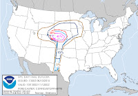
SPC has issued a slight risk for severe weather today across portions of Texas, Oklahoma and Kansas.  High instability will develop bring a retreating warm front across Oklahoma and northern Texas this afternoon. Very high CAPE numbers > 4,500 and EHI values >3 will create an environment cable of explosive storms if they do develop. With the lack of any main triggers in the atmosphere storms will have to rely on small boundaries and just instability maxes. On the map above I have highlighted the SPC slight risk zone and in the pink my highest threat zone for later today.  Right now expect storms if they do form to start building around 5pm. I'll have other update later this afternoon. -Justin-

Monday, May 10, 2010

Significant Outbreak Possible Across OK and KS Today

Not going to get into the details because all the parameters we look at for severe weather is in the high to extreme level. Especially across northern and central Oklahoma into southern parts of Kansas. I'll be out chasing for the station so my chasing area is a little limited to south of OKC to the Red River and west of I-35.
Here is the latest SPC outlook
Will be out chasing around 2:30pm Central time so make you check out the streaming video. Click on the link above marked Live Chase Cams.

Sunday, May 9, 2010

Severe Weather Likely Tomorrow but Shifting East of Texoma

I'll wait for tomorrow before I give the details of this severe weather setup and where I plan on chasing for the station. In the meantime here is a map that I made this morning based on Saturday evening's 0z runs of the models......The current trends continue to press the dryline and 850 trough to the east. So storms will likely form on or just east of I-44 from OKC south to the Red River.

Friday, May 7, 2010

Threat Increases Today Across Ohio Valley

Threat continues to increases across Indiana and Ohio for Super Cells and possible tornadoes by Mid to Late Afternoon. Here is the Latest Outlook from SPC.

Monday, May 3, 2010

11th Anniversary of the Moore, Oklahoma F5 Tornado


On May 3, 1999, multiple supercell thunderstorms produced many large and damaging tornadoes in central Oklahoma during the late afternoon and evening hours. Some of these storms were killers, including the twisters which moved through and/or near Dover, Shawnee, Perry and Bridge Creek, and the Moore and southern Oklahoma City metropolitan areas. Additional tornadoes also hit areas in south central Kansas, eastern Oklahoma and northern Texas, with over 70 tornadoes being observed across the region, and some tornadoes occurring the during the morning and early afternoon hours of May 4, 1999. The total tornado count in Oklahoma makes the May 3-4, 1999 tornado outbreak the largest ever recorded in the state.

Click Here to read the full story from the Norman National Weather Service.

If you want to see a great video of the Tornado.....
Click Here for a minute to minute encounter from Channel 4 in OKC of their coverage.....I have watched this video several times and I still get goosebumps and a lump in my throat. I love the power and mystery of tornadoes and enjoy watching them in open fields. However my drive as a meteorologist is to help better predict them and to warm the public of the pending danger. God Bless all 44 people that died on this horrible day in Oklahoma history.

Here is another great Two part summary of the tornado from KWTV the station that the Gary England works at. Part 1   Part 2

Click Here for a collage of views of the Moore, Oklahoma F5 tornado