Warmer temperatures and a different weather pattern is starting to show early Spring conditions across the Central Plains today. A small but potent storm system comes out of the Rockies into Nebraska and Kansas during peak heating. A more potent storm system moves into the Southern Plains Sunday and into Monday. This will have more moisture and better dynamics to deal with. Heavy rains look likely from N.Texas north to Southern Kansas during Sunday. However a cold core setup with a dryline looks possible on Monday. Many questions still out there with the quality of moisture, lapse rates, morning convection and cloud cover. However the first chase of the year for me could be days away but right now its only a slight chance. =)
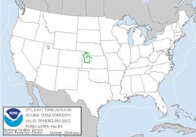
Here below is the tornado threat and write up from SPC.
A 40-45KT LLJ HAS DEVELOPED ACROSS CENTRAL HIGH PLAINS IN RESPONSE
TO THE LEE TROUGHING ERN CO AHEAD OF THE S/WV TROUGH. ALTHOUGH LOW
LEVEL MOISTURE IS MARGINAL MOVING NWD THRU THE HIGH PLAINS...THE
COMBINATION OF VERY STEEP MID LEVEL LAPSE RATES...8C/KM OR
GREATER...AND COLD AIR ALOFT WILL BE MORE THAN SUFFICIENT TO SUPPORT
THUNDERSTORM DEVELOPMENT BY OR SHORTLY AFTER PEAK HEATING.
WITH SURFACE TEMPERATURES CLIMBING THRU THE 60S IN WRN KS AND
DEWPOINTS RISING INTO THE MID 40S...MUCAPES WILL STILL ONLY BE ABLE
TO REACH TO AROUND 500 J/KG BY 21Z AHEAD OF THE DEVELOPING N/S DRY
LINE FAR WRN KS.
SURFACE BOUNDARY FORECASTED TO MOVE EWD AHEAD OF UPPER SYSTEM ERN CO
DURING THE AFTERNOON WILL LIKELY BE THE PRIMARY FOCUS FOR CONVECTIVE
INITIATION AS IT OVERTAKES THE DRY LINE IN WRN KS INTO SWRN NEB.
GIVEN THE COLD AIR ALOFT AND STEEP LAPSE RATES...HAIL WILL BE LIKELY
ASSOCIATED WITH ANY STRONG UPDRAFT. THERE IS THE POSSIBILITY GIVEN
THE LARGE SCALE UPPER SUPPORT AND VEERING SHEAR PROFILES...THAT
STRONGER STORMS WILL BE ABLE TO BRIEFLY ROTATE INCREASING THE THREAT
OF LARGER HAIL AND EVEN A BRIEF FUNNEL AND/OR TORNADO.
CONCERN FOR ANY MARGINALLY SEVERE STORMS SHOULD END BY EVENING AS
LOW LEVEL LAPSE RATES WEAKEN WITH ACTIVITY MOVING EWD TOWARD
SCENTRAL NEB/NCENTRAL KS.
..HALES/ROGERS.. 03/05/2010


No comments:
Post a Comment