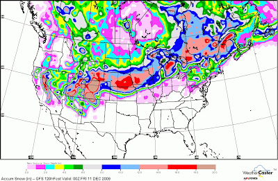
As mentioned over a month ago and have been talked about several times over the last week. A major blizzard is in the works but may be a little further north then I expected it to be. The missed forecast by me is because of the very strong high pressure in Canada being a little further north. So what this is doing or not doing I should say is dropping the front further south with a push of cold air. So the low pressure will likely come out of Colorado and ride the front/baroclinic zone east then northeast. There is a very strong jet stream with this system and besides the heavy snows there will likely be winds over 60mph in spots. Here is a couple graphics to show the path and the latest snowfall map by the GFS. I still think there is time to adjust the storm track a little further south. So the track of the low pressure from far northeast New Mexico east to far Northeast Oklahoma to Southwest Illinois(near St. Louis) northeast into Lower Michigan near Detroit. What I still expect and has been forecasted is another low pressure to bomb out off the Northeast coast. Probably developing just off the North Carolina coast then hugging the coast as it deepens to the notheast.


No comments:
Post a Comment