Wednesday, November 17, 2010

Better Get Those Xmas Lights Up Now...

Here comes the Arctic Chill as forecasted earlier this month on here...See Forecast Post

Per NAO and AO as you can see below which would indicate arctic intrusion and trough in the east.


And it looks like this will continue into the start of December as higher pressures in Alaska continues the arctic slide south with the NAO staying negative.

Looking towards Thanksgiving week, an arctic wave drifting south will meet up with an Pacific system. This will likely pull the bitterly cold air sitting to the north southward. As a wave of low pressure or a couple waves slides along the front while the cold air drifts south and east. Models continue to disagree on the evolution of cold air and storm system. However it looks like you definitely need to get those Christmas lights up if you live in the east. The cold is coming and looks to be sticking around for a while as the month of December looks pretty cold from the Mississippi river east.

Here are examples of the two main long range models the GFS(US Model) and the EURO( European). Right now I believe the 500mb pattern looks better on the Euro than the GFS. The GFS is sending too much energy ahead of the main trough (feedback). This will in turn help pump the ridge across the southeast and help phase the jet streams to dig in the trough as it slides east.


Trust me I'm tracking this closely because Laura and I will be flying on Thanksgiving day back to Indy. 
Monday, November 8, 2010

The Cold Builds to the North as Active Jet Stream Moves In

As mentioned last week, an active pattern is setting up across the central portion of the US. Current temperatures during the warmest part of the day are quite cold across Canada as you can see below.

This build up of cold air is just asking to be sent south and some will over the next couple of weeks. The kicker will be an active jet stream and low pressure across the interior west of the United States. The cold air looks to come down in waves so will likely modify some as it heads south. So portions of the central Plains could see snow falling by this upcoming weekend (north of I-70).

As several areas of low pressure come out of the west and head east/northeast towards the Great Lakes. Producing rain and some storms from the Southern Plains northeast into the Great Lakes region. Now this will just be the first of likely 3 or 4 storms over the next two weeks. Each one producing heavy rains but each one will likely press the snow line to the south. Right now the ensembles and long range models continue to point to a very cold(relative to average) mid month and Thanksgiving week across most of the US.

So anyone from the Texas Panhandle to Louisville to New York City and points to the north better be on guard for shoveling snow by Thanksgiving week. Places east of the Mississippi will likely see the real cold air not arrive till Thanksgiving week. So here comes the cold air as it will likely feel like late December in the third week of November. So I warned you and you better get those thermal long johns ready.

Here is the latest 8-14 day analomy and the latest 8-14 day outlook from CPC

Wednesday, November 3, 2010

Here Comes Winter....With A Sneak Peak This Weekend

The first nor'easter of the year is about to develop across the East as cold modified air rushes in from Canada. This will likely produce the first snow flurries all across the Ohio Valley and eventually as far south as the Appalachians and into the interior Northeast.


What I have my eyes on is a developing cold air mass in NW Canada and Pacific Jet stream that will likely buckle by mid month. As we could see our first major snowstorm of the year from the Central Plains and East into the Mid-Atlantic. Followed by freezing temperatures into the south from Texas to Georgia as temperatures could be in the single digits to teens across the north. Right now the time of arrival for this first major bout of winter looks to arrive between the 13th-16th of the month. Below is first the latest ensemble run of the 500mb anomaly and the latest 8-14 anomaly composite.

Tuesday, October 26, 2010

Historic Storm Continues to Deepen!

This is a storm now stronger than the infamous "Edmund Fitzgerald" storm in Nov. 1975 and an even stronger version almost exactly 23 years after that in Nov. 1998. Its central pressure is also on par with the infamous Superstorm of 1993, and is lower than the last 4 hurricanes of the 2010 Atlantic hurricane season. Currently the pressure is down to 957mb which puts it second on the list of lowest pressure ever in this part of the region. To reach number one it will have to fall another 7 millibars to beat the Great Ohio Blizzard of 1978. Forecast show it reaching 955mb before starting to fill back in.
Here is a map of all the currents wa

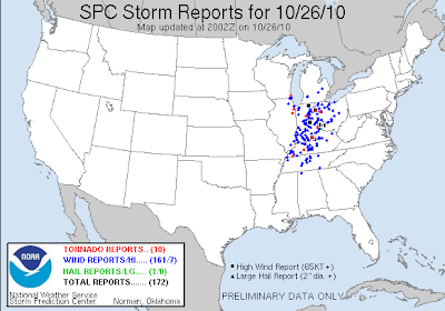
It continues to spawn numerous severe t'storms with damaging winds and tornadoes from Ohio and Pennsylvania south to Mississippi,Alabama and Georgia. Here is the latest map of all the storm reports so far.  
This threat will continue well into the evening as the low pressure finally starts to weaken and move into southern Canada.

Life Threatening Event Unfolding Across Ohio Valley

SPC Now has a large portion of Indiana under a High Risk for later this morning. As a large line of severe t'storms continue to race to the east across Illinois currently. This will meet up with increasingly warm and moist air as the morning wears on. Creating a very potent and a potentially life threatening situation with damaging winds and strong tornadoes looking likely. I'll have more details later this morning when I get time. I'm currently watching this from work but am very impressed by some of the parameters I'm looking at. These storms will be rocketing along at over 60 mph and the high winds/tornadoes will be surrounded by heavy rains making them nearly impossible to see. BE CAREFUL AND PAY ATTENTION TO THE LATEST WARNINGS!

Monday, October 25, 2010

Leaf Stripping Wind Machine Starts to Crank Up

Statement from the Chicago National Weather Service
PUBLIC INFORMATION STATEMENT
NATIONAL WEATHER SERVICE CHICAGO/ROMEOVILLE IL
1030 AM CDT MON OCT 25 2010

HOW THE UPCOMING CYCLONE RANKS AMONG OTHER NOTABLE CYCLONES OVER THE
GREAT LAKES.


RANK EVENT DATE MINIMUM CENTRAL PRESSURE
1. GREAT OHIO BLIZZARD 1/26/1978 950 HPA /28.05 IN/
2. UPCOMING EVENT 10/26-27/2010 959 HPA* /28.35 IN/
3. ARMISTICE DAY STORM 11/11/1940 967 HPA /28.55 IN/
ANNIVERSARY STORM 11/10/1998 967 HPA /28.55 IN/
4. CYCLONE OF 1913 11/7-9/1913 968 HPA /28.60 IN/
/AKA WHITE HURRICANE/
5. EDMUND FITZGERALD STORM 11/10/1975 980 HPA /28.95 IN/
* AVERAGE AMONG SEVERAL CURRENT FORECAST MODELS


Likely one of the deepest areas of low pressure ever recorded in the Great Lakes region by tomorrow afternoon is starting to really deepen. As the pressures continue to fall, winds continue to increase all across the Plains and eventually to the east across the Ohio valley and Great Lakes. Winds in the atmosphere are extremely strong with this storm system from top to bottom. So winds outside of any t'storm could exceed 50 mph today across the Plains and over 70mph across the Great Lakes and Ohio Valley. Unfortunately my computer is not allowing me to post any pictures to my blog but I'll try to get them on later.

Now of course the severe weather threat is on the higher side with this storm system based on the difference of temperatures, wind energy and plenty of moisture surging north from the Gulf of Mexico. Today's target area is across the mid Mississippi Valley from eastern Iowa and Missouri during this afternoon then quickly racing east across Wisconsin, Illinois and Arkansas overnight.

Then by tomorrow morning the likely squall line will continue to surge eastward across Indiana, southern Michigan, Kentucky and Ohio during the day on Tuesday. This line will have numerous reports of damaging winds and the possibility of brief tornadoes. This is a possible dangerous situation across the upper and middle Mississippi Valley and into the Great Lakes and Ohio Valley on Tuesday. Please make sure you keep up with the weather as conditions will change very quickly.