Tuesday, May 11, 2010

More Severe Weather Today?

SPC has issued a slight risk for severe weather today across portions of Texas, Oklahoma and Kansas.  High instability will develop bring a retreating warm front across Oklahoma and northern Texas this afternoon. Very high CAPE numbers > 4,500 and EHI values >3 will create an environment cable of explosive storms if they do develop. With the lack of any main triggers in the atmosphere storms will have to rely on small boundaries and just instability maxes. On the map above I have highlighted the SPC slight risk zone and in the pink my highest threat zone for later today.  Right now expect storms if they do form to start building around 5pm. I'll have other update later this afternoon. -Justin-

Monday, May 10, 2010

Significant Outbreak Possible Across OK and KS Today

Not going to get into the details because all the parameters we look at for severe weather is in the high to extreme level. Especially across northern and central Oklahoma into southern parts of Kansas. I'll be out chasing for the station so my chasing area is a little limited to south of OKC to the Red River and west of I-35.
Here is the latest SPC outlook
Will be out chasing around 2:30pm Central time so make you check out the streaming video. Click on the link above marked Live Chase Cams.

Sunday, May 9, 2010

Severe Weather Likely Tomorrow but Shifting East of Texoma

I'll wait for tomorrow before I give the details of this severe weather setup and where I plan on chasing for the station. In the meantime here is a map that I made this morning based on Saturday evening's 0z runs of the models......The current trends continue to press the dryline and 850 trough to the east. So storms will likely form on or just east of I-44 from OKC south to the Red River.

Friday, May 7, 2010

Threat Increases Today Across Ohio Valley

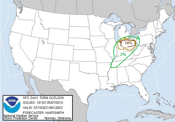
Threat continues to increases across Indiana and Ohio for Super Cells and possible tornadoes by Mid to Late Afternoon. Here is the Latest Outlook from SPC.

Monday, May 3, 2010

11th Anniversary of the Moore, Oklahoma F5 Tornado


On May 3, 1999, multiple supercell thunderstorms produced many large and damaging tornadoes in central Oklahoma during the late afternoon and evening hours. Some of these storms were killers, including the twisters which moved through and/or near Dover, Shawnee, Perry and Bridge Creek, and the Moore and southern Oklahoma City metropolitan areas. Additional tornadoes also hit areas in south central Kansas, eastern Oklahoma and northern Texas, with over 70 tornadoes being observed across the region, and some tornadoes occurring the during the morning and early afternoon hours of May 4, 1999. The total tornado count in Oklahoma makes the May 3-4, 1999 tornado outbreak the largest ever recorded in the state.

Click Here to read the full story from the Norman National Weather Service.

If you want to see a great video of the Tornado.....
Click Here for a minute to minute encounter from Channel 4 in OKC of their coverage.....I have watched this video several times and I still get goosebumps and a lump in my throat. I love the power and mystery of tornadoes and enjoy watching them in open fields. However my drive as a meteorologist is to help better predict them and to warm the public of the pending danger. God Bless all 44 people that died on this horrible day in Oklahoma history.

Here is another great Two part summary of the tornado from KWTV the station that the Gary England works at. Part 1   Part 2

Click Here for a collage of views of the Moore, Oklahoma F5 tornado
Monday, April 26, 2010

4-22-10 Chase #2 Summary

Chase #2 of the Season Summary- Success

A Slight risk eventually become a moderate for our area by the 20z update from SPC. So Finally a decent setup and it lived up to it's billing as our first intersect of a tornado of the year. Although be it several miles away it was the best we could do with the lack of roads. It also didn't help that the beast was in the middle of no where cruising at less than 10 mph at times.

My Co-Anchor on Good Morning Texoma, Lindsay Vocht and I went west as my normal chase partner Oliver was on vacation. It was also Lindsay's first chasing experience and I was dealing with a brand new laptop. So we definitely got off to a bumpy start as my laptop was not liking my Verizon wireless card. Thankfully by time the storms got going we were able to fix the problems and headed southwest to Childress. Which was my original chase target since Tuesday of that week. So I was pleased that my forecast was verifying.

Once we arrived in Childress it was evident that this supercell was really getting its act together so we went after it in Motley county. Which at this time the storm went tornado warned and we arrived about ten minutes later. A large wall cloud and tornado was easily recognizable in the distance however was quickly cover up by rain. Over the next two hours we continued to watch this beast travel northeast at first at 25mph then slowly down to less than 10mph.  This storm produced a large rain-wrapped tornado that was reported by spotters southwest of Cee Vee. This storm continued to produce one or more tornadoes as it tracked to the southeast of Cee Vee between 7:30 and 8:40 pm.
Here is rough edit of some of the better video we got on this storm.

Lindsay put together a funny summary of our chasing adventure...Enjoy!
For more videos...Check out the Chase Videos Link Above!
Here is a report from the NWS-Lubbock about this Tornado Supercell Click Here-Report

Here is a great write up from the West Texas Mesonet of storm damage and estimate of the tornado. Click Here-TORNADO DAMAGE
 
Miles Travels- 382   (566 for the year)
Tornadoes Witnessed- One Large Wedge
Largest Hail- Quarter Size (1 inch)
High Windsest. 40 mph

Full List of Storm Reports for 4-22-10 Click Here