Check it out and leave a comment below telling me what you think about their prediction.
AccuWeather Tornado Season Prediction

Wednesday, March 31, 2010
Wednesday, March 24, 2010
Severe Wx Drifts South of Texoma
No chase took place today as the front continued to slide south and east throughout the morning. As some storm did fire up down across I-20 Abilene and drifted east through the Dallas Fort Worth area. Hail has been reported but reports have been minimal and on the small side. So deciding not to chase was a good decision as this set up never really materialized like was expected. Saturday will be the next small chance of severe weather across the southern plains. However this risk is looking very small due to early timing of the front on Saturday and limited moisture.
Looking ahead to next week the Plains finally start to warm up while the Gulf of Mexico starts to recover. These warm temperatures under dry weather and south winds will likely start to bring much higher dew points north. Severe weather starts to become a focus possibly by the end of next week with a major trough into the Pacific Northwest.
Stay Tuned! One of the slowest starts to the tornado season could start ramping up by early to mid April. If you’re curious if the season will ever really get going. I’m seeing some previous analogs suggesting that May and June could be very active across the Plains.
-Justin-
Tuesday, March 23, 2010
Increasing Severe Weather Threat Tomorrow?
Increasing south winds and weak cyclone genesis has been up able to pull northward higher dew points across Texas and the Gulf coast then models have been projecting. This being said SPC has placed a slight risk for severe weather for tomorrow across north Texas. I’ll have more on this possible risk of severe weather later….
-Justin-

-Justin-

Friday, March 19, 2010
One More Winter Blitz before Spring Takes Over!
Major late winter/early spring storm developing across the Southern Plains over the next 24-48 hours. As yet another winter storm hits the state of Oklahoma with blizzard conditions. Currently south winds ahead of the front with mostly sunny skies have warmed temperatures into the 60s and 70s. These south winds are introducing some moisture into the atmosphere and with a strong cold front plummeting south. Scattered strong to locally severe storms will quickly develop late this afternoon and evening. The area being watched for some stronger storms is across sw Oklahoma and parts of north Texas. See Map below....

Then as the strong cold front surges south cold air will drain in taking temperatures from the 70s into the 30s within hours. Then as the upper level low dives into North Texas and a surface low redevelops across far northeast Texas. Moderate to Heavy snow will develop from the Texas Panhandle and expand east across Oklahoma. The snow will be very heavy at times and with the upper level low stalling out. Where ever the band sets up will be capable of snowfall amounts over 6 inches. Here is my current thinking this early afternoon of what snowfall amounts will be by Sunday morning.
***Keep in mind some of this will melt on contact especially the southern edge of the snow. So places along and south of the Red River where snow is not as heavy will see less accumulations**

Don't forget there will also be north winds 20-40mph with even higher gusts at times. So blizzard conditions are pretty likely across central and northern Oklahoma. This cold weather will surge south well into Texas with snow showers Saturday afternoon as far south as Abilene and Dallas along I-20. Crazy 36 hours for me here across Texoma and I'll post an update or two if I get a chance. Holy cow I’m so ready for spring to be here as I'm so over winter!
Take care and have a great Friday everyone. -Justin-
Friday, March 12, 2010
Brief Chase Summary from 3-8-10
Here is a brief summary of the chase on Monday March 8th. Conditions had been questionable for the days leading up to the event. However with the long winters lull getting to us my buddy Matt and I decided to head out. We both wanted to get out and make sure all the equipment was working properly. As he now has live streaming setup on his computer and in his truck.
The chase started in Lawton, Oklahoma and headed west on highway 62 towards our target area Altus, Ok. The question was if the atmosphere could recover fast enough after the late morning and early afternoon strong line of showers and t’storms. Matt and I headed west at around 2:30pm as cloudy skies and light rain continued to fall. However once we got about 30 miles west of Lawton skies began to clear and the sun came out giving us hope. Once arriving in Altus we could see a nice cu field starting to get agitated along the dry line. Radar was also starting to verify that the storms were slowly starting to break out and head northeast. You’ll see a couple pictures in the slide show below of what becomes the Hammon supercell. We noticed the nice storm going up be also didn’t want to chase that further away from home in a questionable atmosphere. Especially when there was a flanking line of cu to the south that was moving towards a warming environment with lots of sunshine. Believe if I had known I would have been fine getting home at midnight and sleeping a couple hours before work.
Well those couple of storms jetted north and eventually produced some severe weather reports with that well photographed tornado in Hammon. Which is about 2 hrs north of Altus and about 3 ½ hrs from Lawton if that is any consolation to our decision. Overall we had a blast and it was good to just drive around looking for storms and enjoying good company. I guess its good say I got my first bust out of the way early. =)
CHASE #1 BUST
Miles 183 No Hail, No Wind over 50, No Tornadoes.
Only some CG and moderate rain shower
Thursday, March 11, 2010
Low Risk of Severe Weather in Ohio Valley


Severe Threat Today In Ohio Valley and Gulf States
Just quick update on the severe weather possible today across Illinois, Indiana and Kentucky today. There is also another area of severe weather that is possible from Louisana, Mississippi, Alabama and Florida. Here is the map of the latest SPC outlook that only has a see text across Indiana and Illinois. Moisture and instability are limiting factors but with strong winds aloft and cold air aloft. A little sunshine will do the trick and with the morning convective line racing northeast that may just happen. Stay tuned!! Another update will be posted early this afternoon for the people up in Ohio Valley.
-Justin-

-Justin-

Monday, March 8, 2010
Questionable Chase out in SW OKlahoma-Follow US
Follow us Chasing via Live Streaming

Heading West towards Altus to see if the dry slot fires up something nice towards sunset. Right now dryline has stalled across far western Oklahoma. As temperatures continue to rebound slowly behind a line of showers and thunderstorms. Will the atmosphere recover enough to produce something nice, time will tell but enjoy the nice view from our camera. All I know is the sunshine that we just broke into feels amazing. Let me know what you think of the streaming video down below.
-Justin-
First Chase of 2010?

Justin
Friday, March 5, 2010
Could We Break the Tornado Drought Today?
Warmer temperatures and a different weather pattern is starting to show early Spring conditions across the Central Plains today. A small but potent storm system comes out of the Rockies into Nebraska and Kansas during peak heating. A more potent storm system moves into the Southern Plains Sunday and into Monday. This will have more moisture and better dynamics to deal with. Heavy rains look likely from N.Texas north to Southern Kansas during Sunday. However a cold core setup with a dryline looks possible on Monday. Many questions still out there with the quality of moisture, lapse rates, morning convection and cloud cover. However the first chase of the year for me could be days away but right now its only a slight chance. =)
Here below is the tornado threat and write up from SPC.
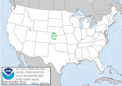 A 40-45KT LLJ HAS DEVELOPED ACROSS CENTRAL HIGH PLAINS IN RESPONSE
TO THE LEE TROUGHING ERN CO AHEAD OF THE S/WV TROUGH. ALTHOUGH LOW
LEVEL MOISTURE IS MARGINAL MOVING NWD THRU THE HIGH PLAINS...THE
COMBINATION OF VERY STEEP MID LEVEL LAPSE RATES...8C/KM OR
GREATER...AND COLD AIR ALOFT WILL BE MORE THAN SUFFICIENT TO SUPPORT
THUNDERSTORM DEVELOPMENT BY OR SHORTLY AFTER PEAK HEATING.
WITH SURFACE TEMPERATURES CLIMBING THRU THE 60S IN WRN KS AND
DEWPOINTS RISING INTO THE MID 40S...MUCAPES WILL STILL ONLY BE ABLE
TO REACH TO AROUND 500 J/KG BY 21Z AHEAD OF THE DEVELOPING N/S DRY
LINE FAR WRN KS.
SURFACE BOUNDARY FORECASTED TO MOVE EWD AHEAD OF UPPER SYSTEM ERN CO
DURING THE AFTERNOON WILL LIKELY BE THE PRIMARY FOCUS FOR CONVECTIVE
INITIATION AS IT OVERTAKES THE DRY LINE IN WRN KS INTO SWRN NEB.
GIVEN THE COLD AIR ALOFT AND STEEP LAPSE RATES...HAIL WILL BE LIKELY
ASSOCIATED WITH ANY STRONG UPDRAFT. THERE IS THE POSSIBILITY GIVEN
THE LARGE SCALE UPPER SUPPORT AND VEERING SHEAR PROFILES...THAT
STRONGER STORMS WILL BE ABLE TO BRIEFLY ROTATE INCREASING THE THREAT
OF LARGER HAIL AND EVEN A BRIEF FUNNEL AND/OR TORNADO.
CONCERN FOR ANY MARGINALLY SEVERE STORMS SHOULD END BY EVENING AS
LOW LEVEL LAPSE RATES WEAKEN WITH ACTIVITY MOVING EWD TOWARD
SCENTRAL NEB/NCENTRAL KS.
..HALES/ROGERS.. 03/05/2010
Here below is the tornado threat and write up from SPC.

TO THE LEE TROUGHING ERN CO AHEAD OF THE S/WV TROUGH. ALTHOUGH LOW
LEVEL MOISTURE IS MARGINAL MOVING NWD THRU THE HIGH PLAINS...THE
COMBINATION OF VERY STEEP MID LEVEL LAPSE RATES...8C/KM OR
GREATER...AND COLD AIR ALOFT WILL BE MORE THAN SUFFICIENT TO SUPPORT
THUNDERSTORM DEVELOPMENT BY OR SHORTLY AFTER PEAK HEATING.
WITH SURFACE TEMPERATURES CLIMBING THRU THE 60S IN WRN KS AND
DEWPOINTS RISING INTO THE MID 40S...MUCAPES WILL STILL ONLY BE ABLE
TO REACH TO AROUND 500 J/KG BY 21Z AHEAD OF THE DEVELOPING N/S DRY
LINE FAR WRN KS.
SURFACE BOUNDARY FORECASTED TO MOVE EWD AHEAD OF UPPER SYSTEM ERN CO
DURING THE AFTERNOON WILL LIKELY BE THE PRIMARY FOCUS FOR CONVECTIVE
INITIATION AS IT OVERTAKES THE DRY LINE IN WRN KS INTO SWRN NEB.
GIVEN THE COLD AIR ALOFT AND STEEP LAPSE RATES...HAIL WILL BE LIKELY
ASSOCIATED WITH ANY STRONG UPDRAFT. THERE IS THE POSSIBILITY GIVEN
THE LARGE SCALE UPPER SUPPORT AND VEERING SHEAR PROFILES...THAT
STRONGER STORMS WILL BE ABLE TO BRIEFLY ROTATE INCREASING THE THREAT
OF LARGER HAIL AND EVEN A BRIEF FUNNEL AND/OR TORNADO.
CONCERN FOR ANY MARGINALLY SEVERE STORMS SHOULD END BY EVENING AS
LOW LEVEL LAPSE RATES WEAKEN WITH ACTIVITY MOVING EWD TOWARD
SCENTRAL NEB/NCENTRAL KS.
..HALES/ROGERS.. 03/05/2010
Wednesday, March 3, 2010

Monday, March 1, 2010
The Unofficial Start of Storm Season and Meteorological Spring
Welcome to the unofficial start of storm season for the lower 48 states. Oh ya by the way it’s the start of meteorological spring as well. Typically by the start of March we start to see the storm track a little further north and storm become a little stronger. As the battle of air masses starts to heat up as daylight hours really start to lengthen.
Right now the United States has seen a fairly chilly winter and looks to remain that way generally for the next 2 to 3 weeks. So expect some warmer temperatures as average highs are starting to move up the thermometer but I wouldn't expect any record highs in the near future. As you can see high temperatures continue to be fairly chilly across the US.

Now that we're into March we'll have to closely watch each storm closer for the chances of severe weather. Right now all is quiet for the next 4 to 5 days but by early next week severe weather could develop with a strong low pressure in the Central Plains.
Stay Tuned!
Justin
Subscribe to:
Posts (Atom)