Thursday, January 29, 2009

Quiet conditions until a possible Blizzard next week

While portions of the country dig out from a major ice and snow storm. An even better storm may be in the works that would be the big daddy to the previous storm. As I mentioned on the January 19th blog the trough east of Japan was starting to develop and would signal a trough along the east coast within 6-10 days of it maturing. That would mean the start of February and the models are all on board for a major trough to develop in the east. As all three jet streams have a chance to phase into a blockbuster storm up the Appalachians or just to the east of them. The upper level pattern is resembling them of the blockbuster storm know as the Superstorm or Blizzard of 1993. Which was one of the worst winter storms of the century with crippling snow and hurricane force winds. Now right now I'm not predicting that or anything up to the level but its an eye opener when you see things like this come together. Here is an comparison of the 1993 500mb map a day before the storm and here is the map predicted in 63 hours from now. Here is the latest GFS model 92 hr. Surface map with two examples of storm tracks. Track #1 is an stronger storm that phases all three jet streams as the low turns more northward as it deepens. Track #2 is probably the more likely storm track. Which takes the low more east then north as the upper levels especially the Arctic Jet stream is slower to phase together. So the low pressure slowly deepens until it hits the warmer Atlantic coast. As the warm coastal waters act like a natural baroclinic zone to strengthen and attract the storm to. Both of the storm tracks are subject to change but both yield very heavy snows and possible severe weather for the southeast coast. Blizzard like conditions will develop but will it be across the Ohio Valley and along the west side of the Appalachians or will it be on the east side of them? This has big potential and will be watched closely over the next couple of days. If you live east of the Mississippi River you'll need to watch closely to the weather forecast over the next week. This could produce heavy snow from Tennessee northeast to Maine with blizzard conditions.

Wednesday, January 28, 2009

Couple Photos from Lawton and the Ice storm here

Just a couple pictures taken this morning from around my apartment of the ice and snow. Click on the link to see the entire album of pictures. PHOTOS

Winter Storm Continues to move east.

The big winter storm continues to move to the northeast as snow and ice is winding down across Indiana, Western Kentucky and Western Tennessee and points to the west. Here is latest Radar view of the mammoth storm that has a ton of moisture but thankfully not wrapped up to produce strong winds with it. Statement from the National Weather Service in Indianapolis

January 2009- Ties for 6th Largest Snow Storm in Indianapolis
"As of 9:30 AM on the 28th, Indianapolis International Airport has received 12.5 inches of snow since the storm began late Monday.This brings this year's storm into the top 10 largest snow storms on record in the Indianapolis Area.

This ties this for the 6th largest snow total for a storm in Indianapolis.
The last time a bigger snowstorm struck the airport was when12.8 inches fell in January 1996. The Great Blizzard of January 1978 dumped 15.5 inches of snow on the airport. The record snowfall for the Indianapolis area is 16.1 inches set in February 1910.

Looking at the big picture, as of 8 am central and southern Indiana had received from 6 to nearly 13 inches of snow since late Monday. Snowfall totals in southern Indiana were reduced some because 1/4 to 3/4 inch of ice also fell.
"
Here is a look at the predicted snow cover across the United States by tomorrow morning. A large area of snow is covering over half of the U. S. as our predicted stormy pattern is just now getting under way. Focus over the next two weeks shift to the coast with mainly coastal storms. The Plains look to warm up and remain pretty dry as troughs and stormy weather will along the coasts.

Tuesday, January 27, 2009

Winter Storm Update

Unfortunately I haven't been able to update with any additional information. As down here in southwest Oklahoma we have been dealing with an ice storm so i have worked 25 hours in the past two days. Currently we're still receiving light to moderate sleet. As freezing rain accumulated starting Monday morning before changing over to sleet overnight last night a little under a quarter of a inch. Then we had heavy sleet with thunder and lightning around sunrise this morning. The sleet has continued to fall but at a weaker pace throughout the day. As it has accumulated around 2inch on top of the ice and has made things around here an absolute mess.

This storm continues to strengthen and head east northeast spreading plenty of ice and snow in its path. My previous snowfall and ice predictions look pretty good for now. I do see a heavy band of snow across Southern Illinois northeast through southern and central Indiana into Ohio. Within this area a general 8-10 inches will fall with possible reports of 14 inches. Sleet may mix in at times so that might lower the total amounts. South of this snow is an severe ice storm across portions of Missouri, Kentucky and eventually into West Virginia. Eventually this storm will effect the east coast from Washington D.C north to Boston with ice and snow.

Have fun digging out!

Sunday, January 25, 2009

Winter Storm starts to take shape

The advertised winter storm from over 10 days ago is just now starting to put its pieces together. As you can see by the map above numerous Winter Storm Watches and Warning have already been posted. They extend from the West Coast and into the Rocky Mountains east across the Plains and Ohio Valley. The track of the storm will be vital on where the snow and Ice line sets up. Right now the greatest Ice accumulation looks to run from East Central Oklahoma northeast through southern Missouri and into Kentucky. North of this line there will likely be a general 4-7 inch snowfall from northeast Oklahoma through Missouri, southern Illinois, Indiana, Ohio and northern Kentucky . Isolated 8 to 10 inch amounts are possible within the band of snow where T'storms get pulled up into the cold air. Here is a quick look at tomorrow recipe of weather as the energy starts to kick out of the West. Main event will get going Monday evening through Wednesday into the Mid-Atlantic states. I'll try to post another update by Monday afternoon with some quick links you can click on to keep you informed. If I see any big changes or special situations I'll post but if not. Keep up to date with short term weather forecast through your local TV, radio and national weather service. I would love to forecast every location for the entire storm but I just don't have the time.

**Quick Note of interest*** I have made a couple changes on the website and have included a Weather Center area on the bottom of the website. Right now its mostly the Southern Plains but I do plan on expanding it. Please feel free to let me know what you think and what you would like to see.... Thanks Justin Cecrudy@yahoo.com

Monday, January 19, 2009

Winter's Arctic air relaxes as a stormier pattern develops

The cold air will begin to relax across the Plains and East over the next two weeks. As a pattern change takes over that will promote a stormier pattern but a little warmer one. Here is a look back at December's Temperature Departure from Average. As you can see Arctic air ruled from the Northern and Central Plains east towards the Great Lakes and Ohio Valley. As the Core of the Cold weather was In northern Montana, North Dakota and Minnesota.

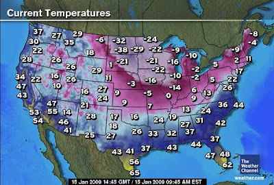
The coldest air has shifted a little more south and east in the first 17 days of January. As you can see by the graphic below bitterly cold temperatures across Minnesota and Wisconsin with temperature averaging below normal by 6 to 9 degrees.

Here is a look at the Ensemble forecast for the next two weeks. Looking at the forecasted NAO, PNA and AO an pattern change will start to take place this week. However it won't really be felt in earnest till the start of February as the cold weather will fight against the impending warmth.

Looking below the trough east of Hawaii is a good indicator for a trough to remain in the east. So until its replaced with a ridge troughs will never stick into the West Coast. As blocking remains across Greenland and over the top of the Pole. Making the cold air continue to funnel in underneath the blocking and into the United States.

By the end of the month, a ridge starts to replace the trough east of Hawaii that will allow any trough diving south in the West to anchor itself. However blocking remains over Greenland but starts to break down and be replaced with a trough. Now a large ridge over the Pacific in this position doesn't normally promote a large trough along the West Coast. Instead it intensifies the northern branch jet which is fire housed into the West Coast as an active pattern starts to develop across the lower 48 states. As cold or near average cold stays to the north and warmer weather starts to develop along the southern states.

Large trough starts to develop in the far East along China and Japan by the start of February. Which is a good indicator for Troughs along the West and East Coast. The ridge remains over Hawaii as an southern jet stream starts to become a little more active per this pattern and MJO phase by the start of February. Blocking starts to build over Greenland as Cold weather regains strength over Northern Asia across the North pole into Northwest Canada. So if the Jet stream can buckle, it will likely send another Arctic blast into the lower 48 states by early to mid February.

So in general the cold weather but not bitterly like the last two weeks will rule over the next 10 days but will begin to weaken by the end of the month. As warmer weather and a pattern flip takes place for at least the start of February. So we up the ante for bigger storms and an very active pattern that will likely last into mid February.

Thursday, January 15, 2009

Just as advertised the Siberian Express is here

This map shows enough to prove that the North Pole has moved south. Some of the coldest temperatures since the Arctic Outbreak back in January of 1994. Stay warm!

Friday, January 9, 2009

Siberian Express is heading south so get ready

Brutal cold air is aimed for much of the lower 48 states over the next two weeks. As a large ridge builds across the Pacific and west coast of the US and Canada. Will dislodge temperatures right now across Alaska and the Yukon territory of Canada in the range of -40 to -60 degrees below zero.
As the weak La Nina mentioned in the Winter Outlook has been confirmed by the Climate Prediction Center. Here is the general storm track and weather for a La Nina. Can you see the similarities to our weather pattern for the past 60 days?
During the next two weeks a ridge will build in the West and a big trough will dive into the East. Causing plenty of cold air to overwhelm the Plains east to the East coast. As the Polar vortex will head south and will likely be in the Great Lakes by next weekend. This will cause days across the Northern Plains to never reach above the teens below zero. Chicago and portions of the Ohio Valley to have high temperatures near zero degrees. Even down into Texas and the Gulf Coast high temperatures could be in the teens and twenties. This cold outbreak could be the coldest since the extreme outbreak in January of 1994.
Now before the Siberian Express shows up we have to deal with an Alberta Clipper with some Arctic air behind it for the weekend. As the low pressure will race southeast to around St Louis by midnight tonight and then east towards the Mid Atlantic states by tomorrow afternoon. Here is snowfall map that shows the general thinking of snowfall over the next 48 hours.


Here is one of the computer models predicted high temperatures for next Thursday 15th...Brrr!

Monday, January 5, 2009

Winter weather holds on but much colder weather is ahead

An sloppy area of low pressure continues to slowly strengthen across eastern Texas. This will spread storms, rain, ice and snow from the Mississippi Valley into the Ohio Valley. Ice and Snow will accumulate across the Ohio Valley especially across I-70 area. Accumulations look less than a quarter inch of Ice and less than 4 inches of snow. So this doesn't look like very big storm at all and will be out of the area within 12hrs from the precip starting. Some light precipitation could linger around the Ohio Valley during the day on Wednesday.

Looking ahead a even colder pattern will start to set up across the east as a retrogression pattern will set up. So the coldest air compared to the means(averages) will be across the Northeast then will shift westward over the next two weeks. As by the 15th a very cold air mass could be entrenched from the Plains to the East Coast. Now if you're not enjoying the cold air then you'll like what is ahead. A big pattern change will occur by the end of January with temperatures above normal across the east. So if you make through the next 2-3 weeks then winters coldest will be a thing of the past.